Chapter 1
Lithosphere is the solid crust or the hard top layer of the earth. It is made up of rocks and minerals and covered by a thin layer of soil. It is an irregular surface with various landforms such as mountains, plateaus, plains, valleys, etc. Landforms are found over the continents and also on the ocean floors.
Plant and animal kingdom together make biosphere or the living world. It is a narrow zone of the earth where land, water and air interact with each other to support life.
All plants, animals and human beings depend on their immediate surroundings. Often they are also interdependent on each other. This relation between the living organisms, as well as the relation between the organisms and their surroundings form an ecosystem. There could be an ecosystem of large rain forest, grassland, desert, mountains, lake, river, ocean and even a small pond.
Chapter 2
The deepest mine in the world, is in South Africa. It is about 4 km. deep. In search for oil engineers have dug a hole about 6 km. deep.
To reach to the centre of the earth (which is not possible!) you will have to dig a hole 6000 km. deep on the ocean floor.
INTERIOR OF THE EARTH
The uppermost layer over the earth’s surface is called the crust. It is the thinnest of all the layers. It is about 35 km. on the continental masses and only 5 km. on the ocean floors.
The main mineral constituents of the continental mass are silica and alumina. It is thus called sial (si-silica and al-alumina). The oceanic crust mainly consists of silica and magnesium; it is therefore called sima (si-silica and ma-magnesium) (Fig. 2.2).
The main mineral constituents of the continental mass are silica and alumina. It is thus called sial (si-silica and al-alumina). The oceanic crust mainly consists of silica and magnesium; it is therefore called sima (si-silica and ma-magnesium) (Fig. 2.2).
Just beneath the crust is the mantle which extends up to a depth of 2900 km.
The crust forms only 0.5 per cent of the volume of the earth, 16 per cent consists of the mantle and 83 per cent makes the core.
The radius of the earth is 6371 km.
The radius of the earth is 6371 km.
The innermost layer is the core with a radius of about 3500 km. It is mainly made up of nickel and iron and is called nife (ni – nickel and fe – ferrous i.e. iron). The central core has very high temperature and pressure.
Any natural mass of mineral matter that makes up the earth’s crust is called a rock. Rocks can be of different colour, size and texture.
There are three major types of rocks: igneous rocks, sedimentary rocks and metamorphic rocks.
When the molten magma cools, it becomes solid. Rocks thus formed are called igneous rocks. They are also called primary rocks. There are two types of igneous rocks: intrusive rocks and extrusive rocks.
When this molten lava comes on the earth’s surface, it rapidly cools down and becomes solid. Rocks formed in such a way on the crust are called extrusive igneous rocks. They have a very fine grained structure. For example, basalt. The Deccan plateau is made up of basalt rocks.
Sometimes the molten magma cools down deep inside the earth’s crust. Solid rocks so formed are called intrusive igneous rocks. Since they cool down slowly they form large grains. Granite is an example of such a rock. Grinding stones used to prepare paste/powder of spices and grains are made of granite.
Rocks roll down, crack, and hit each other and are broken down into small fragments. These smaller particles are called sediments. These sediments are transported
and deposited by wind, water, etc. These loose sediments are compressed and hardened to form layers of rocks. These types of rocks are called sedimentary rocks. For example, sandstone is made from grains of sand. These rocks may also contain fossils of plants, animals and other micro- organisms that once lived on them.
Igneous and sedimentary rocks can change into metamorphic rocks under great heat and pressure (Fig. 2.3). For example, clay changes into slate and limestone into marble.

Rocks are made up of different minerals. Minerals are naturally occurring substances which have certain physical properties and definite chemical composition. Minerals are very important to humankind. Some are used as fuels. For example, coal, natural gas and petroleum. They are also used in industries – iron, aluminium, gold, uranium, etc, in medicine, in fertilisers, etc.
Chapter 3
The lithosphere is broken into a number of plates known as the Lithospheric plates. You will be surprised to know that these plates move around very slowly – just a few millimetres each year. This is because of the movement of the molten magma inside the earth. The molten magma inside the earth moves in a circular manner as shown in the activity.
The movement of these plates causes changes on the surface of the earth. The earth movements are divided on the basis of the forces which cause them. The forces which act in the interior of the earth are called as Endogenic forces and the forces that work on the surface of the earth are called as Exogenic forces.

Lithospheric plates:
The earth’s crust consists of several large and some small, rigid, irregularly- shaped plates (slabs) which carry continents and the ocean floor.
Similarly, when the Lithospheric plates move, the surface of the earth vibrates. The vibrations can travel all round the earth. These vibrations are called earthquakes. The place in the crust where the movement starts is called the focus. The place on the surface above the focus is called the epicentre. Vibrations travel outwards from the epicentre as waves. Greatest damage is usually closest to the epicentre and the strength of the earthquake decreases away from the centre.
There are three types of earthquake waves:
P waves or
longitudinal waves
S waves or
transverse waves
L waves or surface
waves
Some common earthquake prediction methods adopted locally by people include studying animal behaviour; fish in the ponds get agitated, snakes come to the surface.
longitudinal waves
S waves or
transverse waves
L waves or surface
waves
Some common earthquake prediction methods adopted locally by people include studying animal behaviour; fish in the ponds get agitated, snakes come to the surface.
An earthquake is measured with a machine called a seismograph. The magnitude of the earthquake is measured on the Richter scale. An earthquake of 2.0 or less can be felt only a little. An earthquake over 5.0 can cause damage from things falling. A 6.0 or higher magnitude is considered very strong and 7.0 is classified as a major earthquake.
Major Land forms
The landscape is being continuously worn away by two processes – weathering and erosion. Weathering is the breaking up of the rocks on the earth’s surface. Erosion is the wearing away of the landscape by different agents like water, wind and ice. The eroded material is carried away or transported by water, wind, etc. and eventually deposited. This process of erosion and deposition create different landforms on the surface of the earth.
There are thousands of small waterfalls in the world. The highest waterfall is Angel Falls of Venezuela in South America. The other waterfalls are Niagara falls located on the border between Canada and USA in North America and Victoria Falls on the borders of Zambia and Zimbabwe in Africa.
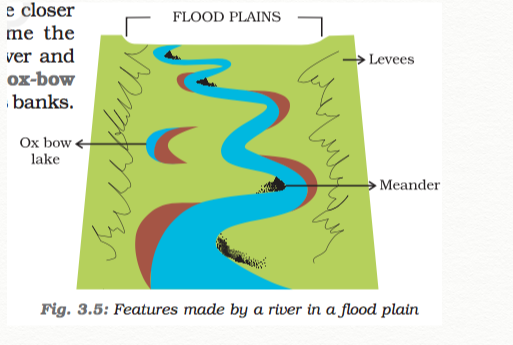
As the river enters the plain it twists and turns forming large bends known as meanders. Due to continuous erosion and deposition along the sides of the meander, the ends of the meander loop come closer and closer. In due course of time the meander loop cuts off from the river and
forms a cut-off lake, also called an ox-bow lake. At times the river overflows its banks.
This leads to the flooding of the neighbouring areas. As it floods, it
deposits layers of fine soil and other material called sediments along its
banks. This leads to the formation of a flat fertile floodplain. The raised
banks are called levees. As the river approaches the sea, the speed of the
flowing water decreases and the river begins to break up into a number of streams called distributaries. The river becomes so slow that it begins to deposit its load. Each distributary forms its own mouth. The collection of sediments from all the mouths forms a delta.
Work of sea waves
The erosion and deposition of
the sea waves gives rise to coastal landforms. Seawaves continuously strike at the rocks. Cracks develop. Over time they become larger and wider. Thus, hollow like caves are formed on the rocks. They are called sea caves. As these cavities become bigger and bigger only the roof of the caves remain, thus forming sea arches. Further, erosion breaks the roof and only walls are left.These wall like features are called stacks. The steep rocky coast rising almost vertically above sea water is called sea cliff. The sea waves deposit sediments along the shores forming beaches.

Work of Ice
Glaciers are “rivers” of ice which too erode the landscape by bulldozing soil and stones to expose the solid rock below. Glaciers carve out deep hollows. As the ice melts they get filled up with water and become beautiful lakes in the mountains. The material carried by the glacier such as rocks big and small, sand and silt gets deposited. These deposits form glacial moraines.
Work of wind
An active agent of erosion and deposition in the deserts is wind. In deserts you can see rocks in the shape of a mushroom, commonly called mushroom rocks. Winds erode the lower section of the rock more than the upper part. Therefore, such rocks have narrower base and wider top. When the wind blows, it lifts and transports sand from one place to another. When it stops blowing the sand falls and gets deposited in low hill – like structures. These are called sand dunes . When the grains of sand are very fine and light, the wind can carry it over very long distances. When such sand is deposited in large areas, it is called loess. Large deposits of loess is found in China.
Chapter 4
Carbon dioxide released in the atmosphere creates a green house effect by trapping the heat radiated from the earth. It is therefore called a greenhouse gas and without it the earth would have been too cold to live in. However, when its level in the atmosphere increases due to factory smoke or car fumes, the heat retained increases the temperature of the earth. This is called global warming. This rise in temperature causes the snow in coldest parts of the world to melt. As a result the sea level rises, causing floods in the coastal areas. There may be drastic changes in the climate of a place leading to extinction of some plants and animals in the long run.
All living beings on this earth depend on the atmosphere for their survival. It provides us the air we breathe and protects us from the harmful effects of the sun’s rays. Without this blanket of protection, we would be baked alive by the heat of the sun during day and get frozen during night.
Nitrogen is the most plentiful gas in the air. When we inhale, we take some amount of nitrogen into our lungs and exhale it. But plants need nitrogen for their survival. They can not take nitrogen directly from the air. Bacteria, that live in the soil and roots of some plants, take nitrogen from the air and change its form so that plants can use it.
STRUCTURE OF THE ATMOSPHERE
Our atmosphere is divided into five layers starting from the earth’s surface. These are Troposphere, Stratosphere, Mesosphere, Thermosphere and Exosphere
Troposphere: This layer is the most important layer of the atmosphere. Its average height is 13 km. The air we breathe exists here. Almost all the weather phenomena like rainfall, fog and hailstorm occur in
this layer.
Stratosphere: Above the troposphere lies the stratosphere. It extends up to a height of 50 km. This layer is almost free from clouds and associated weather phenomenon, making conditions most ideal for flying aeroplanes. One important feature of stratosphere is that it contains a layer of ozone gas. We have just learnt how it protects us from the harmful effect of the sun rays.
Mesosphere: This is the third layer of the atmosphere. It lies above the stratosphere. It extends up to the height of 80 km. Meteorites burn up in this layer on entering from the space.
Thermosphere: In thermosphere temperature rises very rapidly with increasing height. Ionosphere is a part of this layer. It extends between 80-400 km. This layer helps in radio transmission. In fact, radio waves transmitted from the earth are reflected back to the earth by this layer.
Exosphere: The upper most layer of the atmosphere is known as exosphere. This layer has very thin air. Light gases like helium and hydrogen float into the space from here.
Temperature
The temperature you feel everyday is the temperature of the atmosphere. The degree of hotness and coldness of the air is known as temperature.
An important factor that influences the distribution of temperature is insolation. Insolation is the incoming solar energy intercepted by the earth.
The amount of insolation decreases from the equator towards the poles. Therefore, the
temperature decreases in the same manner. Now do you understand why poles are covered with snow?
The concrete and metals in buildings and the asaphalt of roads get heated up during the day. This heat is released during the night.
Also, the crowded high rise buildings of the cities trap the warm air and thus raise the temperature of the cities.
Air Pressure
You will be surprised to know that air above us presses us with a great force on our bodies. However, we don’t even feel it. This is because the air presses us from all directions and our body exerts a counter pressure.
The air pressure is highest at sea level and decreases with height.
Horizontally the distribution of air pressure is influenced by temperature of air at a given place. In areas where temperature is high the air gets heated and rises. This creates a low-pressure area. Low pressure is associated with cloudy skies and wet weather.
In areas having lower temperature, the air is cold. It is therefore heavy. Heavy air sinks and creates a high pressure area. High pressure is associated with clear and sunny skies.
The air always moves from high pressure areas to low pressure areas.
On the moon there is no air and hence no air pressure.
Astronauts have to wear special
protective space suits filled with air when they go to the moon. If they did not wear these space suits, the counter pressure exerted by the body of the astronauts would make the blood vessels burst. The astronauts would bleed.
Wind
A wind is named after the direction from which it blows, e.g. the wind blowing from the west is called westerly.
Winds can be broadly divided into three types.
1. Permanent winds – The trade winds, westerlies and easterlies
are the permanent winds. These blow constantly throughout the year in a particular direction.
are the permanent winds. These blow constantly throughout the year in a particular direction.
2. Seasonal winds – These winds change their direction in different seasons. For example monsoons in India
3. Local winds – These blow
only during a particular period of the day or year in a small area. For example, land and sea breeze. Do you recall the hot and dry local wind of northern planes of India? It is called loo.
only during a particular period of the day or year in a small area. For example, land and sea breeze. Do you recall the hot and dry local wind of northern planes of India? It is called loo.

Cyclone
Odisha, located on the eastern seacoast of India is prone to
cyclones that originate in the Bay of Bengal. On 17-18
October 1999, cyclone hit five districts of the state. Another
supercyclone occurred on the 29 October 1999, that
devastated large portions of the state. The damages caused
were mainly due to three factors: wind velocity, rain and
tidal surge. The winds of upto 260 km. per hour lasted for over 36 hours.
Heavy rain occurred under the influence of the cyclone for three days continuously. These rains led to flooding in the major rivers of Odisha
The cyclonic winds caused tidal waves that swept 20 km. inland and brought massive destruction to the coastal areas. The 7 to 10 m high tidal wave intruded suddenly and caused massive damage to the standing paddy crops.
Standing crops of paddy, vegetables and fruits were heavily damaged. Due to salinisation caused by tidal surge, large tracts of agricultural land have turned infertile. Large tracts of sal, teak and bamboo plantations have disappeared. The mangrove forests between Paradeep and Konark vanished.
Moisture
When water evaporates from land and different water bodies, it becomes water vapour. Moisture in the air at any time, is known as humidity. When the air is full of water vapour we call it a humid day. As the air gets warmer, its capacity to hold the water vapour increases and so it becomes more and more humid. On a humid day, clothes take longer to dry and sweat from our body does not evaporate easily, making us feel very uncomfortable.
On the basis of mechanism, there are three types of rainfall: the convectional rainfall, the orographic rainfall and the cyclonic rainfall

Chapter 5
Terrarium: It is an artificial enclosure for keeping small house plants.
Salinity is the amount of salt in grams present in 1000 grams of water. The average salinity of the oceans is 35 parts per thousand.
Dead sea in Israel has salinity of 45 parts per thousand. Swimmers can float
in it because the increased salt content makes it dense.
March 22 is celebrated as World Water Day when the need to conserve water is reinforced in different ways.
The movements that occur in oceans can be broadly categorised as: waves, tides and currents.
Waves are formed when winds scrape across the ocean surface. The stronger the wind blows, the bigger the wave becomes.
When the water on the surface of the ocean rises and falls alternately, they are called waves.
Tsunami is a Japanese word that means “Harbour waves” as the harbours get destroyed whenever there is tsunami.
An earthquake, a volcanic eruption or underwater landslides can shift large amounts of ocean water. As a result a huge tidal wave called tsunami, that may be as high as 15m., is formed. The largest tsunami ever measured was 150m. high. These waves travel at a speed of more than 700 km. per hour. The tsunami of 2004 caused wide spread damage in the coastal areas of India. The Indira point in the Andaman and Nicobar islands got submerged after the tsunami.
The wave was the result of the earthquake that had its epicenter close to the western boundary of Sumatra. The magnitude of the earthquake was 9.0 on the Richter scale
Tsunami travelled at a speed of about 800km. per hour, comparable to speed of commercial aircraft and completely washed away some of the islands in the Indian ocean. The Indira point in the Andaman and Nicobar islands that marked the southernmost point of India got completely submerged.
While the earthquake cannot be predicted in advance, it is possible to give a three-hour notice of a potential tsunami. Such early warning systems are in place across the Pacific ocean, but not in the Indian Ocean. Tsunamis are rare in the Indian Ocean as the seismic activity is less as compared to the Pacific.
Tides
The rhythmic rise and fall of ocean water twice in a day is called a tide. It is high tide when water covers much of the shore by rising to its highest level. It is low tide when water falls to its lowest level and recedes from the shore.
The strong gravitational pull exerted by the sun and the moon on the earth’s surface causes the tides. The water of the earth closer to the moon gets pulled under the influence of the moon’s gravitational force and causes high tide. During the full moon and new moon days, the sun, the moon and the earth are in the same line and the tides are highest. These tides are called spring tides. But when the moon is in its first and last quarter, the ocean waters get drawn in diagonally opposite directions by the gravitational pull of sun and earth resulting in low tides. These tides are called neap tides (Fig. 5.5).

High tides help in navigation. They raise the water level close to the shores. This helps the ships to arrive at the harbour more easily. The high tides also help in fishing. Many more fish come closer to the shore during the high tide. This enables fishermen to get a plentiful catch. The rise and fall of water due to tides is being used to generate electricity in some places.
Ocean Currents
Ocean currents are streams of water flowing constantly on the ocean surface in definite directions. The ocean currents may be warm or cold (Fig. 5.6). Generally, the warm ocean currents originate near the equator and move towards the poles. The cold currents carry water from polar or higher latitudes to tropical or lower latitudes. The Labrador Ocean current is cold current while the Gulf Stream is a warm current. The ocean current influence the temperature conditions of the area. Warm currents bring about warm temperature over land surface. The areas where the warm and cold currents meet provide the best fishing grounds of the world. Seas around Japan and the eastern coast of North America are such examples. The areas where a warm and cold current meet also experience foggy weather making it difficult for navigation.

Chapter 6
The tropical evergreen forest in Brazil is so enormous that it is like the lungs of the earth:
Anaconda, one of the world’s largest snakes is found in the tropical rainforest. It can kill and eat a large animal such as a crocodile.
Tropical Evergreen Forests
These forests are also called tropical rainforests (Fig. 6.3). These thick forests occur in the regions near the equator and close to the tropics. These regions are hot and receive heavy rainfall throughout the year. The thick canopies of the closely spaced trees do not allow the sunlight to penetrate inside the forest even in the day time. Hardwood trees like rosewood, ebony, mahogany are common here.
Tropical Deciduous Forests
Tropical deciduous are the monsoon forests found in the large part of India,northern Australia and in central America (Fig. 6.4).These regions experience seasonal changes. Trees shed their leaves in the dry season to conserve water. The hardwood trees found in these forests are sal, teak, neem and shisham. Hardwood trees are extremely useful for making furniture, transport and constructional materials. Tigers, lions, elephants, langoors and monkeys are the common animals of these regions
Temperate Evergreen Forests
The temperate evergreen forests are located in the mid- latitudinal coastal region (Fig. 6.7). They are commonly found along the eastern margin of the continents, e.g., In south east USA, South China and in South East Brazil. They comprise both hard and soft wood trees like oak, pine, eucalyptus, etc.
Temperate Deciduous Forests
As we go towards higher latitudes, there are more temperate deciduous forests (Fig. 6.11). These are found in the north eastern part of USA, China, New Zealand, Chile and also found in the coastal regions of Western Europe. They shed their leaves in the dry season. The common trees are oak, ash, beech, etc. Deer, foxes, wolves are the animals commonly found. Birds like pheasants, monals are also found here
Mediterranean Vegetation
You have learnt that most of the east and north east margins of the continents are covered by temperate evergreen and deciduous trees. The west and south west margins of the continents are different. They have Mediterranean vegetation (Fig. 6.12). It is mostly found in the areas around the Mediterranean sea in Europe, Africa and Asia, hence the name. This kind of vegetation is also found outside the actual Mediterranean region in California in the USA, south west Africa, south western South America and South west Australia. These regions are marked for hot dry summers and mild rainy winters. Citrus fruits such as oranges, figs, olives and grapes are commonly cultivated here because people have removed the natural vegetation in order to cultivate what they want to. There isn’t much wildlife here.
Coniferous Forests
In the higher latitudes (50° – 70°) of Northern hemisphere the spectacular Coniferous forests are found (Fig. 6.13 a and b). These are also called as Taiga. These forests are also seen in the higher altitudes. These are the trees which Salima found in the Himalayas in abundance. They are tall, softwood evergreen trees. The woods of these trees are very useful for making pulp, which is used for manufacturing paper and newsprint. Match boxes and packing boxes are also made from softwood. Chir, pine, cedar are the important variety of trees in these forests. Silver fox, mink, polar bear are the common animals found here
Taiga means pure or untouched in the Russian language
GRASSLANDS
Tropical grasslands: These occur on either side of the equator and extend till the tropics (Fig. 6.14). This vegetation grows in the areas of moderate to low amount of rainfall. The grass can grow very tall, about 3 to 4 metres in height. Savannah grasslands of Africa are of this type. Elephants, zebras, giraffes, deer, leopards are common in tropical grasslands
Temperate grasslands: These are found in the mid- latitudinal zones and in the interior part of the continents. Usually, grass here is short and nutritious.Wild buffaloes, bisons, antilopes are common in the temperate region.
Grasslands are known by different names in different regions.
Tropical Grasslands
East Africa- Savanna Brazil- Campos Venezuela- Llanos
Temperate Grasslands
Argentina- Pampas N. America- Prairie S. Africa- Veld
C. Asia- Steppe Australia- Down
C. Asia- Steppe Australia- Down
Thorny bushes: These are found in the dry desert like regions.Tropical deserts are located on the western margins of the continents. The vegetation cover is scarce here because of scanty rain and scorching heat. Identify the desert regions in the world map.
If you reach the polar region you will find the place extremely cold. The growth of natural vegetation is very limited here. Only mosses, lichens and very small shrubs are found here. It grows during the very short summer. This is called Tundra type of vegetation. This vegetation is found in the polar areas of Europe, Asia and North America. The animals have thick fur and thick skin to protect themselves from the cold climatic conditions. Seal, walruses, musk-oxen, Arctic owl, Polar bear and snow foxes are some of the animals found here
Chapter 7
Settlements are places where people build their homes.
Settlements can be permanent or temporary.
The four major means of transport are roadways, railways, waterways and airways.
There are several National and State highways in India. The latest development in India is the construction of Express Ways. The Golden Quadrilateral connects Delhi, Mumbai, Chennai and Kolkata.
ROADWAYS
Manali-Leh highway in the Himlayan Mountains is one of the highest roadways in the world. Roads built underground are called subways/under paths. Flyovers are built over raised structures.
The Trans-Siberian Railway is the longest railway system connecting St. Petersburg in Western Russia to Vladivostok on the Pacific coast
WATERWAYS
Waterways are the cheapest for carrying heavy and bulky goods over long distances. They are mainly of two types – inland waterways and sea routes.
Navigable rivers and lakes are used as inland waterways. Some of the important inland waterways are the Ganga-Brahmaputra river system, the Great Lakes in North America and the river Nile in Africa.
Sea routes and oceanic routes are mostly used for transporting merchandise and goods from one country to another. These routes are connected with the ports. Some of the important ports of the world are Singapore and Mumbai in Asia, New York, Los Angeles in North America, Rio de Janerio in South America, Durban and Cape Town in Africa, Sydney in Australia, London and Rotterdam in Europe
AIRWAYS
It is also the most expensive due to high cost of fuels. Air traffic is adversely affected by bad weather like fog and storms. It is the only mode of transport to reach the most remote and distant areas especially where there are no roads and railways. Helicopters are extremely useful in most inaccessible areas and in time of calamities for rescuing people and distributing food, water, clothes and medicines (Fig. 7.9). Some of the important airports are Delhi, Mumbai, New York, London, Paris, Frankfurt and Cairo (Fig. 7.11).
COMMUNICATION
Through newspapers, radio and television we can communicate with a large number of people. They are therefore called mass media. The satellites have made communication even faster. Satellites have helped in oil exploration, survey of forest, underground water, mineral wealth, weather forecast and disaster warning. Now we can send electronic mails or e-mails through Internet. Wireless
telephonic communications through cellular phones have become very popular today.
Chapter 8
When Spanish explorers discovered the Amazon river, they were attacked by a group of local tribes wearing headgears and grass skirts. These people reminded them of the fierce tribes of women warriors known in ancient Roman Empire as the Amazons. Hence the name Amazon.
Tributaries: These are small rivers that join the main river. The main river along with all its tributaries that drain an area forms a river basin or the catchment area. The Amazon Basin is the largest river basin in the world.
Bromeliads are special plants that store water in their leaves. Animals like frogs use these pockets of water for laying their eggs.
LIFE IN THE GANGA-BRAHMAPUTRA BASIN
The tributaries of rivers Ganga and Brahmaputra together form the Ganga-Brahmaputra basin in the Indian subcontinent (Fig. 8.8). The basin lies in the sub-tropical region that is situated between 10°N to 30°N latitudes. The tributaries of the River Ganga like the Ghaghra, the Son, the Chambal, the Gandak, the Kosi and the tributaries of Brahmaputra drain it.
tributaries of the River Brahmaputra?
Wheat, maize, sorghum, gram and millets are the other crops that are grown. Cash crops like sugarcane and jute are also grown. Banana plantations are seen in some areas of the plain. In West Bengal and Assam tea is grown in plantations (Fig. 8.10). Silk is produced through the cultivation of silk worms in parts of Bihar and Assam. In the mountains and hills, where the slopes are gentle, crops are grown on terraces.
In the Ganga and Brahmaputra plain tropical deciduous trees grow, along with teak, sal and peepal. Thick bamboo groves are common in the Brahmaputra plain.
The delta area is covered with the mangrove forests. In parts of Uttarakhand, Sikkim and Arunachal Pradesh, coniferous trees like pine, deodar and fir can be seen because the climate is cool and the slopes are steep.
The one-horned rhinoceros is found in the Brahmaputra plain. In the delta area, Bengal tiger, crocodiles and alligator are found. Aquatic life abounds in the fresh river waters, the lakes and the Bay of Bengal Sea. The most popular varieties of the fish are the rohu, catla and hilsa. Fish and rice is the staple diet of the people living in the area.
In the fresh waters of River Ganga and River Brahmaputra, a variety of dolphin locally called Susu (also called blind dolphin) is found. The presence of Susu is an indication of the
health of the river. The untreated industrial and urban wastes with high amount of chemicals are killing this species.
health of the river. The untreated industrial and urban wastes with high amount of chemicals are killing this species.
Kolkata is an important port on the River Hooghly.
Chapter 9
Life in the Temperate Grasslands
Just as a forest can be defined as the place where trees are the main type of vegetation, grassland can be defined as a region where grasses form the dominant type of plant life. Grasslands make up almost a quarter of the total land surface.
As climate plays an important role in the formation of grasslands, it is generally used as a basis to divide the world’s grasslands into two broad categories: those that occur in the temperate region and those that occur in the tropical regions.
THE PRAIRIES
The temperate grasslands of North America are known as the Prairies
valleys, woodlands can be found. Tall grass, upto two metres high, dominates, the landscape. It is actually a “sea of grass.”
The prairies are bound by the Rocky Mountains in the West and The Great lakes in the east.
Prairies cover parts of United States of America and parts of Canada. In the USA, the area is drained by the tributaries of Mississippi and the Canadian prairies are drained by the tributaries of Saskatchewan Rivers.
Chinook is a hot wind that blows in winter and therefore raises the temperature within a short time. This increase in temperature results in the melting of snow, making pasture land available for grazing of animals.
The summers are warm with temperatures of around 20°C, while in winter -20°C has been recorded in Winnipeg, Canada. In winters a thick blanket of snow covers this region.
The annual rainfall is moderate and is ideal for the growth of grass. Due to the absence of the north-south barrier, a local wind “Chinook” blows here.
FLORA AND FAUNA
Prairies are practically tree-less. Where water is available, trees such as willows, alders and poplars grow. Places that receive rainfall of over 50 cm, are suitable for farming as the soil is fertile. Though the major crop of this area is maize, other crops including potatoes, soybean, cotton and alfa-alfa is also grown. Areas where rainfall is very little or unreliable, grasses are short and sparse. These areas are suitable for cattle rearing. Large cattle farms called ranches are looked after by sturdy men called
cowboys (Fig. 9.3). Bison or the American buffalo is the most important animal of this region (Fig. 9.4). It nearly got extinct due to its indiscriminate hunting and is now a protected species. The other animals found in this region are rabbits, coyotes, gophers and Prairie dog.
cowboys (Fig. 9.3). Bison or the American buffalo is the most important animal of this region (Fig. 9.4). It nearly got extinct due to its indiscriminate hunting and is now a protected species. The other animals found in this region are rabbits, coyotes, gophers and Prairie dog.
Scientific methods of cultivation and use of tractors, harvesters and combines has made North America a surplus food producer. The Prairies are also known as the “Granaries of the world,” due to the huge surplus of wheat production.
Dairy farming is another major industry. The dairy belt extends from the Great Lakes to the Atlantic Coast in the east. Dairy farming and extensive agriculture both promote setting up of food processing industries.
Large mineral deposits particularly coal and iron and a good network of roads, railways and canals in this region have made it the most industrialised region in the world.
THE VELDS
The Veld name was given by the Dutch settlers before South Africa was colonised by the British.
The temperate grasslands of South Africa are called the velds (Fig. 9.5). Velds are rolling plateaus with varying heights ranging from 600 m to 1100 m. It is bound by the Drakensburg Mountains on the east. To its west lies the Kalahari desert. On the northeastern part, “high velds” are located that attain a height of more than 1600 m, in some places. Look at the map of Africa. Name the countries that are covered by the Velds. The tributaries of rivers Orange and Limpopo drain the region.
CLIMATE
The velds have a mild climate due to the influence of the Indian Ocean. Winters are cold and dry. Temperatures vary between 5°C and 10°C and July is the coldest month. Summers are short and warm. Johannesburg records about 20°C temperature in the summer.
The velds receive rainfall mainly in the summer months from November to February. This is mainly because of the warm ocean currents that wash the shores of the velds. If the rainfall is scanty in the winter months from June till August, drought may occur.
Red grass grows in bush velds. In the high velds acacia and maroola are seen to be growing. The animals of the velds are primarily lions, leopards, cheetah and kudu
PEOPLE
Velds are known for cattle rearing and mining. The soils are not very fertile in the velds due to the presence of discontinuous grasses exposing barren surface. However where the land is fertile crops are grown. The main crops are maize, wheat, barley, oats and potato. Cash crops like tobacco, sugarcane and cotton are also grown.
Sheep rearing is the most important occupation of the people. Sheep is bred mainly for wool and has given rise to the wool industry in the velds. Merino sheep is a popular species and their wool is very warm. Dairy farming is the next important occupation
The velds have rich reserve of minerals. Iron and steel industry has developed where coal and iron are present. Gold and diamond mining are major occupations of people of this region. Johannesburg is known for being the gold capital of the world. Kimberley is famous for its diamond mines (Fig. 9.7). Mining of diamond and gold in South Africa led to the establishment of trade ties with Britain and gradually South Africa became a British Colony. This mineral rich area has a well-developed network of transport.
Chapter 10
THE HOT DESERT – SAHARA
Sahara desert covering a large part of North Africa. It is the world’s largest desert. It has an area of around 8.54 million sq. km. Do you recall that India has an area of 3.2 million sq. km? The Sahara desert touches eleven countries. These are Algeria, Chad, Egypt, Libya, Mali, Mauritania, Morocco, Niger, Sudan, Tunisia and Western Sahara.
The climate of the Sahara desert is scorching hot and parch dry. It has a short rainy season. The sky is cloudless and clear.
The temperatures during the day may soar as high as 50°C, heating up the sand and the bare rocks, which in turn radiates heat making everything around hot. The nights may be freezing cold with temperatures nearing zero degrees.
Vegetation in the Sahara desert includes cactus, date palms and acacia. In some places there are oasis – green islands with date palms surrounding them.
Bedouins and Tuaregs. These groups are nomadic tribes rearing livestock such as goats, sheep, camels and horses.
The oasis in the Sahara and the Nile Valley in Egypt supports settled population. Since water is available, the people grow date palms. Crops such as rice, wheat, barley and beans are also grown. Egyptian cotton, famous worldwide is grown in Egypt.
The discovery of oil – a product in great demand throughout the world, in Algeria, Libya and Egypt is constantly transforming the Sahara desert. Other minerals of importance that are found in the area include iron, phosphorus, manganese and uranium.
Depressions are formed when the wind blows away the sands. In the depressions where underground water reaches the surface, an oasis is formed.
Tafilalet Oasis in Morocco is a large oasis with an area of about 13,000 sq.km.
THE COLD DESERT - LADAKH
Ladakh is a cold desert lying in the Great Himalayas, on the eastern side of Jammu and Kashmir (Fig. 10.4). The Karakoram Range in the north and the Zanskar mountains in the south enclose it. Several rivers flow through Ladakh, Indus being the most important among them. The rivers form deep valleys and gorges. Several glaciers are found in Ladakh, for example the Gangri glacier.
The altitude in Ladakh varies from about 3000m in Kargil to more than 8,000m in the Karakoram.
The day temperatures in summer are just above zero degree and the night temperatures well below –30°C.
there is little rainfall, as low as 10 cm every year
Ladakh is also known as Khapa-chan which means snow land.
The Chiru or the Tibetan antelope is an endangered species. It is hunted for its wool known as shahtoosh, which is light in weight and extremely warm.
several Buddhists monasteries dot the Ladakhi landscape with their traditional ‘gompas’. Some famous monasteries are Hemis, Thiksey, Shey and Lamayuru
Leh, the capital of Ladakh is well connected both by road and air. The National Highway 1A connects Leh to Kashmir Valley through the Zoji la Pass. Can you name some more passes in the Himalayas?
Manali - Leh highway crosses four passes, Rohtang la,
Baralacha la Lungalacha la and Tanglang la. The highway opens only between July and September when snow is cleared from the road.
Baralacha la Lungalacha la and Tanglang la. The highway opens only between July and September when snow is cleared from the road.
Life of people is undergoing change due to modernisation. But
the people of Ladakh have over the centuries learned to live in balance and harmony with nature. Due to scarcity of resources like water and fuel, they are used with reverence and care. Nothing is discarded or wasted.
the people of Ladakh have over the centuries learned to live in balance and harmony with nature. Due to scarcity of resources like water and fuel, they are used with reverence and care. Nothing is discarded or wasted.


No comments:
Post a Comment