Chapter 1
POPULATION
Distribution, Density, Growth and Composition
Distribution, Density, Growth and Composition
The people are very important component of a country. India is the second most populous country after China in the world with its total population of 1,028 million (2001). India’s population is larger than the total population of North America, South America and Australia put together. More often, it is argued that such a large population invariably puts pressure on its limited resources and is also responsible for many socio-economic problems in the country.
Such an uneven spatial distribution of population in India suggests a close relationship between population and physical, socio- economic and historical factors. As far as the physical factors are concerned, it is clear that climate along with terrain and availability of water largely determines the pattern of the population distribution. Consequently, we observe that the North Indian Plains, deltas and Coastal Plains have higher proportion of population than the interior districts of southern and central Indian States, Himalayas, some of the north eastern and the western states. However, development of irrigation (Rajasthan), availability of mineral and energy resources (Jharkhand) and development of transport network (Peninsular States) have resulted in moderate to high concentration of population in areas which were previously very thinly populated
Density of population, is expressed as number of persons per unit area
The density of population in India (20011) is 382 persons per sq km and ranks third among the most densely populated countries of Asia following Bangladesh (849 persons) and Japan (334 persons). There has been a steady increase of about 200 persons per sq km over the last 50 years as the density of population increased from 117 persons/ sq km in 1951 to 382 persons/sq km in 2011.
as low as 13 persons per sq km in Arunachal Pradesh to 9,340 persons in the National Capital Territory of Delhi.
Growth of population is the change in the number of people living in a particular area between two points of time. Its rate is expressed in percentage. Population growth has two components namely; natural and induced. While the natural growth is analysed by assessing the crude birth and death rates, the
induced components are explained by the volume of inward and outward movement of people in any given area.
The annual growth rate of India’s population is 2.4 per cent. At this current rate of increase, it is estimated that the country’s population will double itself in another 36 years and even surpass population of China.
Census 2011: Population decadal growth rate declines to 17%
Phase III : The decades 1951-1981 are
referred to as the period of population explosion in India, which was caused by a rapid fall in the mortality rate but a high fertility rate of population in the country. The average annual growth rate was as high as 2.2 per cent. Besides, increased international migration bringing in Tibetans, Bangladeshis, Nepalis and even people from Pakistan contributed to the high growth rate.
Phase IV : In the post 1981 till present, the growth rate of country’s population though remained high, has started slowing down gradually
A downward trend of crude birth rate is held responsible for such a population growth. This was, in turn, affected by an increase in the mean age at marriage, improved quality of life particularly education
of females in the country.
The growth rate of population is, however, still high in the country, and it has been projected by World Development Report that population of India will touch 1,350 million by 2025.
The growth rate of population is, however, still high in the country, and it has been projected by World Development Report that population of India will touch 1,350 million by 2025.
The States like Kerala, Karnataka, Tamil Nadu, Andhra Pradesh, Orissa, Puducherry, and Goa show a low rate of growth not exceeding 20 per cent over the decade. Kerala registered the lowest growth rate (9.4) not only in this group of states but also in the country as a whole.
An important aspect of population growth in India is the growth of its adolescents. At present the share of adolescents i.e. up to the age group of 10-19 years is about 22 per cent (2001), among which male adolescents constitute 53 per cent and female adolescents constitute 47 per cent. The adolescent population, though, regarded as the youthful population having high potentials, but at the same time they are quite vulnerable if not guided and channelised properly. There are many challenges for the society as far as these adolescents are concerned, some of which are lower age at marriage, illiteracy – particularly female illiteracy, school dropouts, low intake of nutrients, high rate of maternal mortality of adolescent mothers, high rates of HIV/AIDS infections, physical and mental disability or retardedness, drug abuse and alcoholism, juvenile delinquency and commitence of crimes, etc.
In view of these, the Government of India has undertaken certain policies to impart proper education to the adolescent groups so that their talents are better channelised and properly utilised. The National Youth Policy is one example which has been designed to look into the overall development of our large youth and adolescent population.
The National Youth Policy of Government of India, launched in 2003, stresses on an all- round improvement of the youth and adolescents enabling them to shoulder responsibility towards constructive development of the country. It also aims at reinforcing the qualities of patriotism and responsible citizenship.
The thrust of this policy is youth empowerment in terms of their effective participation in decision making and carrying the responsibility of an able leader. Special emphasis was given in empowering women and girl child to bring parity in the male-female status. Moreover, deliberate efforts were made
to look into youth health, sports and recreation, creativity and awareness about new innovations in the spheres of science and technology.
Do you know that India has 638,588 villages according to the Census 2001 out of which 593,731 (93 per cent) are inhabited villages
You might have noted that the states like Bihar and Sikkim have very high percentage of rural population. The states of Goa and Maharashtra have only little over half of their total population residing in villages.
The Union Territories, on the other hand, have smaller proportion of rural population,except Dadra and Nagar Haveli (77.1 per cent). The size of villages also varies considerably. It is less than 200 persons in the hill states of north-eastern India, Western Rajasthan and Rann of Kuchchh and as high as 17 thousand persons in the states of Kerala and in parts of Maharashtra.
Contrary to rural population, the proportion of urban population (27.8 per cent) in India is quite low but it is showing a much faster rate of growth over the decades. In fact since 1931, the growth rate of urban population has accelerated due to enhanced economic development and improvement in health and hygienic conditions.
Linguistic Composition
India is a land of linguistic diversity. According to Grierson (Linguistic Survey of India, 1903 – 1928) there were 179 languages and as many as 544 dialects in the country. In the context of modern India, there are about 18 scheduled languages (1991 census) and a number of non- scheduled languages. Among the scheduled languages, the speakers of Hindi have the highest percentage (40.42). The smallest language groups are Kashmiri and Sanskrit speakers (0.01 per cent each). However, it is

Religious Composition
Hindus are distributed as a major group in many states (ranging from 70 - 90 per cent and above) except the districts of states along Indo- Bangladesh border, Indo-Pak border, Jammu & Kashmir, Hill States of North-East and in scattered areas of Deccan Plateau and Ganga Plain.
Muslims, the largest religious minority, are concentrated in Jammu & Kashmir, certain districts of West Bengal and Kerala, many districts of Uttar Pradesh , in and around Delhi and in Lakshadweep. They form majority in Kashmir valley and Lakshadweep.
The Christian population is distributed mostly in rural areas of the country. The main concentration is observed along the Western coast around Goa, Kerala and also in the hill states of Meghalaya, Mizoram, Nagaland, Chotanagpur area and Hills of Manipur.
Sikhs are mostly concentrated in relatively small area of the country, particularly in the states of Punjab, Haryana and Delhi.
Jains and Buddhists, the smallest religious groups in India have their concentration only in selected areas of the country. Jains have major concentration in the urban areas of Rajasthan, Gujarat and Maharashtra, while the Buddhists are concentrated mostly in Maharashtra. The other areas of Buddhist majority are Sikkim, Arunachal Pradesh, Ladakh in Jammu & Kashmir, Tripura, and Lahul and Spiti in Himachal Pradesh.
The other religions of India include Zoroastrians, tribal and other indigenous faiths and beliefs. These groups are concentrated in small pockets scattered throughout the country.

Composition of Working Population
The population of India according to their economic status is divided into three groups, namely; main workers, marginal workers and non-workers.
Main Worker is a person who works for at least 183 days in a year.
Marginal Worker is a person who works for less than 183 days in a year.
The proportion of working population, of the states and Union Territories show a moderate variation from about 25 per cent in Goa to about 53 per cent in Mizoram.
About 58.2 per cent of total working population are cultivators and agricultural labourers, whereas only 4.2% of workers are engaged in household industries and 37.6 % are other workers including non- household industries, trade, commerce, construction and repair and other services. As far as the occupation of country’s male and female population is concerned, male workers out-number female workers in all the three sectors
The number of female workers is relatively high in primary sector, though in recent years there has been some improvement in work participation of women in secondary and tertiary sectors.
It is important to note that the proportion of workers in agricultural sector in India has shown a decline over the last few decades (66.85% in 1991 to 58.2% in 2001).
Consequently, the participation rate in secondary and tertiary sector has registered an increase. This indicates a shift of dependence of workers from farm-based occupations to non- farm based ones, indicating a sectoral shift in the economy of the country.
The population of India, at 1210.2 million.
The percentage decadal growth 14 during 2001-2011 has registered the sharpest decline since Independence – a decrease of 3.90 percentage points from 21.54 to 17.64 percent.
India Sex ratio is 940 as per Census 2011. The sex ratio was 933 as per 2001 population. The sex ratio at 940 is highest Sex Ratio recorded since Census 1971.
Chapter 2
MIGRATION Types, Causes and Consequences
Indian Diaspora
During colonial period (British period) millions of the indentured labourers were sent to Mauritius, Caribbean islands (Trinidad, Tobago and Guyana), Fiji and South Africa by British from Uttar Pradesh and Bihar; to Reunion Island, Guadeloupe, Martinique and Surinam by French and Dutch and by Portuguese from Goa, Daman and Diu to Angola, Mozambique to work as plantation workers. All such migrations were covered under the time-bound contract known as Girmit Act (Indian Emigration Act). However, the living conditions of these indentured labourers were not better than the slaves.
The second wave of migrants ventured out into the neighbouring countries in recent times as professionals, artisans, traders and factory workers, in search of economic opportunities to Thailand, Malaysia, Singapore, Indonesia, Brunei and African countries, etc. and the trend still continues. There was a steady outflow of India’s semi-skilled and skilled labour in the wake of the oil boom in West Asia in the 1970s. There was also some outflow of entrepreneurs, storeowners, professionals, businessmen to Western Countries.
Third wave, of migrant was comprised professionals like doctors, engineers (1960s onwards), software engineers, management consultants, financial experts, media persons (1980s onwards), and others migrated to countries such as USA, Canada, UK, Australia, New Zealand and Germany, etc. These professional enjoy the distinction of being one of highly educated, the highest earning and prospering groups. After liberalisation, in the 90s education and knowledge–based Indian emigration has made Indian Diaspora one of the most powerful diasporas in the world.
In all these countries, Indian diaspora has been playing an important role in the development of the respective countries
In the Census of India migration is enumerated on two bases : (i) place of birth, if the place of birth is different from the place of enumeration (known as life-time migrant); (ii) place of residence, if the place of last residence is different from the place of enumeration (known as migrant by place of last residence). Can you imagine the proportion of migrants in the population of India? As per 2001 census, out of 1,029 million people in the country, 307 million (30 per cent) were reported as migrants by place of birth. However, this figure was 315 million (31 per cent) in case of place of last residence.
In India, during 2001, out of 315 million migrants, enumerated on the basis of the last residence, 98 million had changed their place of residence in the last ten years. Out of these, 81 million were intra- state migrants. The stream was dominated by female migrants. Most of these were migrants related to marriage.
From the distribution of male and female migrants in different streams of intra-state and inter-state migration,It is clearly evident that females predominate the streams of short distance rural to rural migration in both types of migration. Contrary to this, men predominate the rural to urban stream of inter-state migration due to economic reasons.
Apart from these streams of internal migration, India also experiences immigration from and emigration to the neighbouring countries.
Census 2001 has recorded that more than 5 million person have migrated to India from other countries. Out of these, 96 per cent came from the neighbouring countries: Bangladesh (3.0 million) followed by Pakistan (0.9 million) and Nepal (0.5 million). Included in this are 0.16 million refugees from Tibet, Sri Lanka, Bangladesh, Pakistan, Afghanistan, Iran, and Myanmar. As far as emigration from India is concerned it is estimated that there are around 20 million people of Indian Diaspora, spread across 110 countries.
Spatial Variation in Migration
Some states like Maharashtra, Delhi, Gujarat and Haryana attract migrants from other states such as Uttar Pradesh, Bihar, etc. Maharashtra occupied first place in the list with 2.3 million net in-migrants, followed by Delhi, Gujarat and Haryana. On the other hand, Uttar Pradesh (-2.6 million) and Bihar (-1.7 million) were the states, which had the largest number of net out-migrants from the state.
Among the urban agglomeration (UA), Greater Mumbai received the higher number of in migrants.
Causes of Migration
These reasons can be put into two broad categories : (i) push factor, these cause people to leave their place of residence or origin; and (ii) pull factors, which attract the people from different places.
In India people migrate from rural to urban areas mainly due to poverty, high population pressure on the land, lack of basic infrastructural facilities like health care, education, etc. Apart from these factors, natural disasters such as, flood, drought, cyclonic storms, earthquake, tsunami, wars and local conflicts also give extra push to migrate.
On the other hand, there are pull factors which attract people from rural areas to cities. The most important pull factor for majority of the rural migrants to urban areas is the better opportunities, availability of regular work and relatively higher wages. Better opportunities for education, better health facilities and sources of entertainment, etc. are also quite important pull factors.
It can be seen that reason for migration of males and females are different. For example, work and employment have remained the main cause for male migration (38 per cent) while it is only three per cent for the females. Contrary to this, about 65 per cent of females move out from their parental houses following their marriage. This is the most important cause in the rural areas of India except in Meghalaya where reverse is the case.
In comparison to these marriage migration of the male, is only 2 per cent in the country.
Consequences of Migration
Migration is a response to the uneven distribution of opportunities over space. People tend to move from place of low opportunity and low safety to the place of higher opportunity and better safety. This, in turn, creates both benefits and problems for the areas, people migrate from and migrate to. Consequences can be observed in economic, social, cultural, political and demographic terms.
Economic Consequences
A major benefit for the source region is the remittance sent by migrants. Remittances from the international migrants are one of the major sources of foreign exchange. In 2002, India received US$ 11 billion as remittances from international migrants. Punjab, Kerala and Tamil Nadu receive very significant amount from their international migrants.
Migration from rural areas of Eastern Uttar Pradesh, Bihar, Madhya Pradesh and Orissa to the rural areas of Punjab, Haryana, Western Uttar Pradesh accounted for the success of their green revolution strategy for agricultural development.
Besides this, unregulated migration to the metropolitan cities of India has caused overcrowding. Development of slums in industrially developed states such as Maharashtra, Gujarat, Karnataka, Tamil Nadu and Delhi is a negative consequence of unregulated migration within the country.
Age and skill selective out migration from the rural area have adverse effect on the rural demographic structure. However, high out migration from Uttaranchal, Rajasthan, Madhya Pradesh and Eastern Maharashtra have brought serious imbalances in age and sex composition in these states. Similar imbalances are also brought in the recipients states. What is the cause of imbalance in sex ratio in the place of origin and destination of the migrants?
Social Consequences
Migrants act as agents of social change. The new ideas related to new technologies, family planning, girl’s education, etc. get diffused from urban to rural areas through them.
Migration leads to intermixing of people from diverse cultures. It has positive contribution such as evolution of composite culture and breaking through the narrow considerations and widens up the mental horizon of the people at large.
But it also has serious negative consequences such as anonymity, which creates social vacuum and sense of dejection among individuals. Continued feeling of dejection may motivate people to fall in the trap of anti-social activities like crime and drug abuse.
Environmental Consequences
Overcrowding of people due to rural-urban migration has put pressure on the existing social and physical infrastructure in the urban areas. This ultimately leads to unplanned growth of urban settlement and formation of slums shanty colonies.
Apart from this, due to over -exploitation of natural resources, cities are facing the acute problem of depletion of ground water, air pollution, disposal of sewage and management of solid wastes.
Others
Migration (even excluding the marriage migration) affects the status of women directly or indirectly. In the rural areas, male selective out migration leaving their wives behind puts extra physical as well mental pressure on the women. Migration of ‘women’ either for education or employment enhances their autonomy and role in the economy but also increases their vulnerability.
If remittances are the major benefits of migration from the point of view of the source region, the loss of human resources particularly highly skilled people is the most serious cost.
The market for advanced skills has become truly a global market and the most dynamic industrial economies are admitting and recruiting significant proportions of the highly trained professionals from poor regions. Consequently, the existing underdevelopment in the source region gets reinforced.
Chapter 3
HUMAN DEVELOPMENT
With greater familiarity of the city, she could comprehend the paradoxes. The jhuggi and slum clusters, traffic jams, congestion, crimes, poverty, small children begging on traffic lights, people sleeping on footpaths, polluted water and air revealed another face of development. She used to think whether development and under-development coexist? Whether development help some segments of population more than the other? Does development create haves and have nots? Let us examine these paradoxes and try to understand the phenomena.
Of all the paradoxes of our times mentioned in the story, development is the most significant one. Development of a few regions, individuals brought about in a short span of time leads to poverty and malnutrition for many along with large scale ecological degradation. Is development class biased?
Apparently, it is believed that “Development is freedom” which is often associated with modernisation, leisure, comfort and affluence. In the present context, computerisation, industrialisation, efficient transport and communication network, large education system, advanced and modern medical facilities, safety and security of individuals, etc. are considered as the symbols of development. Every individual, community and government measures its performance or levels of development in relation to the availability and access to some of these things. But, this may be partial and one-sided view of development. It is often called the western or euro-centric view of development.
For a postcolonial country like India, colonisation, marginalisation, social discrimination and regional disparity, etc. show the other face of development.
Thus, for India, development is a mixed bag of opportunities as well as neglect and deprivations. There are a few areas like the metropolitan centres and other developed enclaves that have all the modern facilities available to a small section of its population. At the other extreme of it, there are large rural areas and the slums in the urban areas that do not have basic amenities like potable water, education and health infrastructure available to majority of this population.
There is yet another inter-related aspect of development that has direct bearings on the deteriorating human conditions. It pertains to the environmental pollution leading to ecological crisis. Air, soil, water and noise pollutions have not only led to the ‘tragedy of commons’ but these have also threatened the existence of our society. Consequently, the poor are being subjected to three inter -related processes of declining capabilities; i.e.
(1) social capabilities – due to displacement and weakening social ties (social capital),
(2) environmental capabilities – due to pollution and,
(3) personal capabilities – due to increasing incidence of diseases and accidents. This, in turn, has adverse effects on their quality of life and human development.
Based on the above experiences, it can be said that the present development has not been able to address the issues of social injustice, regional imbalances and environmental degradation. On the contrary, it is being widely considered as the prime cause of the social distributive injustices, deterioration in the quality of life and human development, ecological crisis and social unrest. Does development create, reinforce and perpetuate these crises? Thus, it was thought to take up human development as a separate issue against the prevalent western views of development which considers development as the remedy to all the ills including human development, regional disparities and environmental crisis.
Concerted efforts were made to look at development critically at various times in the past. But, most systematic effort towards this was the publication of the First Human Development Report by United Nations Development Programme (UNDP) in 1990. Since then, this organisation has been bringing out World Human Development Report every year. This report does not only define human development, make amendments and changes its indicators but also ranks all the countries of the world based on the calculated scores. According to the Human Development Report 1993, “progressive democratisation and increasing empowerment of people are seen as the minimum conditions for human development”. Moreover, it also mentions that “development must be woven around people, not the people around development” as was the case previously.
What is Human Development?
“Human development is a process of enlarging the range of people’s choices, increasing their opportunities for education, health care, income and empowerment and covering the full range of human choices from a sound physical environment to economic, social and political freedom.”
Thus, enlarging the range of people’s choices is the most significant aspect of human development. People’s choices may involve a host of other issues, but, living a long and healthy life, to be educated and have access to resources needed for a decent standard of living including political freedom, guaranteed human rights and personal self-respect, etc. are considered some of the non-negotiable aspects of the human development.
India continued to rank low in the Human Development Index (HDI), but climbed five notches to the 130th rank in the latest UNDP report on account of rise in life expectancy and per capita income. India ranked 130 among 188 countries in 2014 in Human Development Report.
It was estimated to be more than Rs. 690 per capita per month in States like Punjab, Haryana, Kerala, Maharashtra and Gujarat and below Rs. 520 per capita per month in States like Uttar Pradesh, Bihar, Orissa and Madhya Pradesh, etc. These variations are indicative of some other deep- seated economic problems like poverty, unemployment and under-employment.
The disaggregated data of poverty for the states show that there are States like Orissa and Bihar which have recorded more than 40 per cent of their population living below the poverty line. The States of Madhya Pradesh, Sikkim, Assam, Tripura, Arunachal Pradesh, Meghalaya, Nagaland have more than 30 per cent of their population below poverty line. “Poverty is a state of deprivation. In absolute terms it reflects the inability of an individual to satisfy certain basic needs for a sustained, healthy and reasonably productive living.” Employment rate for educated youth is 25 per cent. Jobless growth and rampant unemployment are some of the important reasons for higher incidences of poverty in India.
Availability of pre and post natal health care facilities in order to reduce infant mortality and post delivery deaths among mothers, old age health care, adequate nutrition and safety of individual are some important measures of a healthy and reasonably long life. India has done reasonably well in some of the health indicators like decline in death rate from 25.1 per thousand in 1951 to 8.1 per thousand in 1999 and infant mortality from 148 per thousand to 70 during the same period. Similarly, it also succeeded in increasing life expectancy at birth from 37.1 years to 62.3 years for males and 36.2 to 65.3 years for females from 1951 to 1999. Though, these are great achievements, a lot needs to be done. Similarly, it has also done reasonably well in bringing down birth rate from 40.8 to 26.1 during the same years, but it still is much higher than many developed countries.
The other significant features of the report are, with the exception of Kerala, the child sex ratio has declined in all the states and it is the most alarming in the developed state of Haryana and Punjab where it is below 800 female children per thousand male children. What factors are responsible for it? Is it the social attitude or scientific methods of sex-determination?
Indicators of Social Empowerment
“Development is freedom”. Freedom from hunger, poverty, servitude, bondage, ignorance, illiteracy and any other forms of domination is the key to human development. Freedom in real sense of the term is possible only with the empowerment and participation of the people in the exercise of their capabilities and choices in the society. Access to knowledge about the society and environment are
fundamental to freedom. Literacy is the beginning of access to such a world of knowledge and freedom.
India's literacy rate is at 74.04%.Kerala is the most literate state in India, with 93.91% literacy. Bihar is the least literate state in India, with a literacy of 63.82%.
It is worth mentioning here that though, there has been improvement in the percentage of literates among the marginalised section yet the gap between the richer and the marginalised sections of the population has increased over the years. Why? Jobless growth
Apart from the educational attainment, the levels of economic development too play significant impacts on HDI. Economically developed states like Maharashtra, Tamil Nadu and Punjab and Haryana have higher value of HDI as compared to states like Assam, Bihar, Madhya Pradesh, etc.
Regional distortions and social disparities which developed during the colonial period continue to play an important role in the Indian economy, polity and society. The Government of India has made concerted efforts to institutionalise the balanced development with its main focus on social distributive justice through planned development. It has made significant achievements in most of the fields but, these are still below the desired level.
Development in general and human development in particular is a complex concept used in social sciences. It is complex because for ages it was thought that development is a substantive concept and once it is achieved it will address all the socio-cultural and environmental ills of the society. Though, development has brought in significant improvement in the quality of life in more than one way but increasing regional disparities, social inequalities, discriminations, deprivations, displacement of people, abuse of human rights and undermining human values and environmental degradation have also increased.
Considering the gravity and sensitivity of the issues involved, the UNDP in its Human Development Report 1993, tried to amend some of the implicit biases and prejudices which were entrenched in the concept of development. People’s participation and their security were the major issues in the Human Development Report of 1993. It also emphasised on progressive democratisation and increasing empowerment of people as minimum conditions for human development. The report recognised greater constructive role of ‘Civil Societies’ in bringing about peace and human development.
The civil society should work for building up opinion for reduction in the military expenditure, de- mobilisation of armed forces, transition from defence to production of basic goods and services and particularly disarmament and reduction in the nuclear warheads by the developed countries. In a nuclearised world, peace and well-being are major global concerns.
At the other extreme of this approach lie the views expressed by the Neo-Malthusians, environmentalists and radical ecologists. They believe that for a happy and peaceful social life proper balance between population and resources is a necessary condition. According to these thinkers, the gap between the resources and population has widened after eighteenth century. There have been marginal expansion in the resources of the world in the last three hundred years but there has been phenomenal growth in the human population. Development has only contributed in increasing the multiple uses of the limited resources of the world while there has been enormous increase in the demand for these resources. Therefore, the prime task before any development activity is to maintain parity between population and resources.
Scholar like Sir Robert Malthus was the first one to voice his concern about the growing scarcity of resources as compared to the human population.
Apparently this argument looks logical and convincing, but a critical look will reveal certain intrinsic flaws such as resources are not a neutral category. It is not the availability of resources that is as important as their social distribution. Resources everywhere are unevenly distributed. Rich countries and people have access to large resource baskets while the poor find their resources shrinking.
Mahatma Gandhi in the recent times advocated the reinforcement of the harmony and balance between the two. He was quite apprehensive about the on-going development particularly the way industrialisation has institutionalised the loss of morality, spirituality, self-reliance, non-violence and mutual co- operation and environment. In his opinion, austerity for individual, trusteeship of social wealth and non-violence are the key to attain higher goals in the life of an individual as well as that of a nation. His views were also re-echoed in the Club of Rome Report “Limits to Growth” (1972), Schumacher’s book “Small is Beautiful” (1974), Brundtland Commission’s Report “Our Common Future” (1987) and finally in the “Agenda-21 Report of the Rio Conference” (1993).
Chapter 4
HUMAN SETTLEMENTS
Settlements vary in size and type. They range from a hamlet to metropolitan cities. With size, the economic character and social structure of settlements changes and so do its ecology and technology.
The basic differences between rural and urban settlements are as follows :
- The rural settlements derive their life support or basic economic needs from land based primary economic activities, whereas, urban settlements, depend on processing of raw materials and manufacturing of finished goods on the one hand and a variety of services on the other.
- Cities act as nodes of economic growth, provide goods and services not only to urban dwellers but also to the people of the rural settlements in their hinterlands in return for food and raw materials. This functional relationship between the urban and rural settlements takes place through transport and communication network.
- Rural and urban settlements differ in terms of social relationship, attitude and outlook. Rural people are less mobile and therefore, social relations among them are intimate. In urban areas, on the other hand, way of life is complex and fast, and social relations are formal.
Rural settlements in India can broadly be put into four types:
- Clustered, agglomerated or nucleated,
- Semi-clustered or fragmented,
- Hamleted, and
- Dispersed or isolated.
Evolution of Towns in India
Towns flourished since prehistoric times in India. Even at the time of Indus valley civilisation, towns like Harappa and Mohenjodaro were in existence. The following period has witnessed evolution of towns. It continued with periodic ups and downs until the arrival of Europeans in India in the eighteenth century. On the basis of their evolution in different periods, Indian towns may be classified as:
• Ancient towns, • Medieval towns, and • Modern towns.
Ancient Towns
There are number of towns in India having historical background spanning over 2000 years. Most of them developed as religious and cultural centres. Varanasi is one of the important towns among these. Prayag (Allahabad), Pataliputra (Patna), Madurai are some other examples of ancient towns in the country.
Medieval Towns
About 100 of the existing towns have their roots in the medieval period. Most of them developed as headquarters of principalities and kingdoms. These are fort towns which came up on the ruins of ancient towns. Important among them are Delhi, Hyderabad, Jaipur, Lucknow, Agra and Nagpur.
Modern Towns
The British and other Europeans have developed a number of towns in India. Starting their foothold on coastal locations, they first developed some trading ports such as Surat, Daman, Goa, Pondicherry, etc. The British later consolidated their hold around three principal nodes – Mumbai (Bombay), Chennai (Madras), and Kolkata (Calcutta) – and built them in the British style.
Towns based on modern industries also evolved after 1850. Jamshedpur can be cited as an example.
After independence, a large number of towns have been developed as administrative headquarters, e.g. Chandigarh, Bhubaneswar, Gandhinagar, Dispur, etc. and industrial centres such as Durgapur, Bhilai, Sindri, Barauni. Some old towns also developed as satellite towns around metropolitan cities such as Ghaziabad, Rohtak, Gurgaon around Delhi. With increasing investment in rural areas, a large number of medium and small towns have developed all over the country.
Urbanisation
Population residing in urban areas in India, according to 1901 census, was 11.4%. This count increased to 28.53% according to 2001 census, and crossing 30% as per 2011 census, standing at 31.16%
Classification of Towns on the basis of Population Size
Census of India classifies urban centres into six classes as presented in Table 4.2. Urban centre with population of more than one lakh is called a city or class I town. Cities accommodating population size between one to five million are called metropolitan cities and more than five million are mega cities. Majority of metropolitan and mega cities are urban agglomerations. An urban agglomeration may consist of any one of the following three combinations: (i) a town and its adjoining urban outgrowths, (ii) two or more contiguous towns with or without their outgrowths, and (iii) a city and one or more adjoining towns with their outgrowths together forming a contiguous spread. Examples of urban outgrowth are railway colonies, university campus, port area, military cantonment, etc. located within the revenue limits of a village or villages contiguous to the town or city.
One-fifth (21.0%) of urban population lives in these mega cities.
Among them, Greater Mumbai is the largest agglomeration with 16.4 million people. Kolkata, Delhi, Chennai, Bangalore and Hyderabad are other mega cities in the country.
Functional Classification of Towns
On the basis of dominant or specialised functions, Indian cities and towns can be broadly classified as follows:
Administrative towns and cities
Towns supporting administrative headquarters of higher order are administrative towns, such as Chandigarh, New Delhi, Bhopal, Shillong, Guwahati, Imphal, Srinagar, Gandhinagar, Jaipur Chennai, etc.
Industrial towns
Industries constitute prime motive force of these cities such as Mumbai, Salem, Coimbatore, Modinagar, Jamshedpur, Hugli, Bhilai, etc.
Transport Cities
They may be ports primarily engaged in export and import activities such as Kandla, Kochchi, Kozhikode, Vishakhpatnam, etc. or hubs of inland transport such as Agra, Dhulia, Mughal Sarai, Itarsi, Katni, etc.
Commercial towns
Towns and cities specialising in trade and commerce are kept in this class. Kolkata, Saharanpur, Satna, etc. are some examples.
Mining towns
These towns have developed in mineral rich areas such as Raniganj, Jharia, Digboi, Ankaleshwar, Singrauli, etc.
Garrison Cantonment towns
These towns emerged as garrisson towns such as Ambala, Jalandhar, Mhow, Babina, Udhampur, etc.
Educational towns
Starting as centres of education, some of the towns have grown into major campus towns such as Roorki, Varanasi, Aligarh, Pilani, Allahabad etc.
Religious and cultural towns
Varanasi, Mathura, Amritsar, Madurai, Puri, Ajmer, Pushkar, Tirupati, Kurukshetra, Haridwar, Ujjain came to prominence due to their religious/cultural significance.
Tourist towns
Nainital, Mussoorie, Shimla, Pachmarhi, Jodhpur, Jaisalmer, Udagamandalam (Ooty), Mount Abu are some of the tourist destinations.
The cities are not static in their function. The functions change due to their dynamic nature.
Chapter 5
LAND RESOURCES AND AGRICULTURE
Human beings thus, use land as a resource for production as well as residence and recreation.
The Survey of India is responsible for measuring geographical area of administrative units in India.
Area under Permanent Pastures and Grazing Lands : Most of this type land is owned by the village ‘Panchayat’ or the Government. Only a small proportion of this land is privately owned. The land owned by the village panchayat comes under ‘Common Property Resources’.
Culturable Waste-Land : Any land which is left fallow (uncultivated) for more than five years is included in this category. It can be brought under cultivation after improving it through reclamation practices.
Current Fallow : This is the land which is left without cultivation for one or less than one agricultural year. Fallowing is a cultural practice adopted for giving the land rest. The land recoups the lost fertility through natural processes.
Fallow other than Current Fallow :
This is also a cultivable land which is left uncultivated for more than a year but less than five years. If the land is left uncultivated for more than five years, it would be categorised as culturable wasteland.
Common Property Resources
Land, according to its ownership can broadly be classified under two broad heads – private land and common property resources (CPRs). While the former is owned by an individual or a group of individuals, the latter is owned by the state meant for the use of the community.
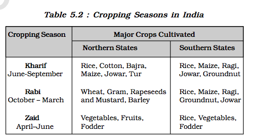
Rainfed farming is further classified on the basis of adequacy of soil moisture during cropping season into dryland and wetland farming. In India, the dryland farming is largely confined to the regions having annual rainfall less than 75 cm. These regions grow hardy and drought resistant crops such as ragi, bajra, moong, gram and guar (fodder crops) and practise various measures of soil moisture conservation and rain water harvesting. In wetland farming, the rainfall is in excess of soil moisture requirement of plants during rainy season. Such regions may face flood and soil erosion hazards. These areas grow various water intensive crops such as rice, jute and sugarcane and practise aquaculture in the fresh water bodies.
Foodgrains
Foodgrains are dominant crops in all parts of the country whether they have subsistence or commercial agricultural economy. On the basis of the structure of grain the foodgrains are classified as cereals and pulses.
Cereals
The cereals occupy about 54 per cent of total cropped area in India. The country produces about 11 per cent cereals of the world and ranks third in production after China and U.S.A. India produces a variety of cereals, which are classified as fine grains (rice, wheat) and coarse grains (jowar, bajra, maize, ragi), etc. Account of important cereals has been given in the following paragraphs :
Rice
Rice is a staple food for the overwhelming majority of population in India. Though, it is considered to be a crop of tropical humid areas, it has about 3,000 varieties which are grown in different agro-climatic regions. These are successfully grown from sea level to about 2,000 m altitude and from humid areas in eastern India to dry but irrigated areas of Punjab, Haryana, western U.P. and northern Rajasthan. In southern states and West Bengal the climatic conditions allow the cultivation of two or three crops of rice in an agricultural year. In West Bengal farmers grow three crops of rice called ‘aus’, ‘aman’ and ‘boro’. But in Himalayas and northwestern parts of the country, it is grown as a kharif crop during southwest Monsoon season.
India contributes 21.6 per cent of rice production in the world and ranked second after China in 2008-09. About one-fourth of
Rice cultivation in the irrigated areas of Punjab and Haryana was introduced in 1970s following the Green Revolution. Genetically improved varieties of seed, relatively high usage of fertilisers and pesticides and lower levels of susceptibility of the crop to pests due to dry climatic conditions are responsible for higher yield of rice in this region. The yield of this crop is very low in rainfed areas of Madhya Pradesh, Chhattisgarh and Odisha.
Wheat
Wheat is the second most important cereal crop in India after rice. India produces about 12 per cent of total wheat production of world. It is primarily a crop of temperate zone. Hence, its cultivation in India is done during winter i.e. rabi season. About 85 per cent of total area under this crop is concentrated in north and central regions of the country i.e. Indo-Gangetic Plain, Malwa Plateau and Himalayas up to 2,700 m altitude. Being a rabi crop, it is mostly grown under irrigated conditions. But it is a rainfed crop in Himalayan highlands and parts of Malwa plateau in Madhya Pradesh.
The yield level of wheat is very high (above 4,000 k.g. per ha) in Punjab and Haryana whereas, Uttar Pradesh, Rajasthan and Bihar have moderate yields. The states like Madhya Pradesh, Himachal Pradesh and Jammu and Kashmir growing wheat under rainfed conditions have low yield.
Jowar
The coarse cereals together occupy about 16.50 per cent of total cropped area in the country. Among these, jowar or sorghum alone accounts for about 5.3 per cent of total cropped area. It is main food crop in semi-arid areas of central and southern India. Maharashtra alone produces more than half of the total jowar production of the country. Other leading producer states of jowar are Karnataka, Madhya Pradesh and Andhra Pradesh. It is sown in both kharif and rabi seasons in southern states. But it is a kharif crop in northern India where it is mostly grown as a fodder crop. South of Vindhyachal it is a rainfed crop and its yield level is very low in this region.
Bajra
Bajra is sown in hot and dry climatic conditions in northwestern and western parts of the country. It is a hardy crop which resists frequent dry spells and drought in this region. It is cultivated alone as well as part of mixed cropping. This coarse cereal occupies about 5.2 per cent of total cropped area in the country. Leading producers of bajra are the states of Maharashtra, Gujarat, Uttar Pradesh, Rajasthan and Haryana. Being a rainfed crop, the yield level of this crop is low in Rajasthan and fluctuates a lot from year to year. Yield of this crop has increased during recent years in Haryana and Gujarat due to introduction of drought resistant varieties and expansion of irrigation under it.
Maize
Maize is a food as well as fodder crop grown under semi-arid climatic conditions and over inferior soils. This crop occupies only about 3.6 per cent of total cropped area. Maize cultivation is not concentrated in any specific region. It is sown all over India except eastern and north-eastern regions. The leading producers of maize are the states of Madhya Pradesh, Andhra Pradesh, Karnataka, Rajasthan and Uttar Pradesh. Yield level of maize is higher than other coarse cereals. It is high in southern states and declines towards central parts.
Pulses
Pulses are a very important ingredient of vegetarian food as these are rich sources of proteins. These are legume crops which increase the natural fertility of soils through nitrogen fixation. India is a leading producer of pulses and accounts for about one-fifth of the total production of pulses in the world. The cultivation of pulses in the country is largely concentrated in the drylands of Deccan and central plateaus and northwestern parts of the country. Pulses occupy about 11 per cent of the total cropped area in the country. Being the rainfed crops of drylands, the yields of pulses are low and fluctuate from year to year. Gram and tur are the main pulses cultivated in India.
Gram
Gram is cultivated in subtropical areas. It is mostly a rainfed crop cultivated during rabi season in central, western and northwestern parts of the country. Just one or two light showers or irrigations are required to grow this crop successfully. It has been displaced from the cropping pattern by wheat in Haryana, Punjab and northern Rajasthan following the green revolution. At present, gram covers only about 2.8 per cent of the total cropped area in the country. Madhya Pradesh, Uttar Pradesh, Maharashtra, Andhra Pradesh and Rajasthan are the main producers of this pulse crop. The yield of this crop continues to be low and fluctuates from year to year even in irrigated areas.
Tur (Arhar)
Tur is the second important pulse crop in the country. It is also known as red gram or pigeon pea. It is cultivated over marginal lands and under rainfed conditions in the dry areas of central and southern states of the country. This crop occupies only about 2 per cent of total cropped area of India. Maharashtra alone contributes about one-third of the total production of tur. Other leading producer states are Uttar Pradesh, Karnataka, Gujarat and Madhya Pradesh. Per hectare output of this crop is very low and its performance is inconsistent.
Oilseeds
The oilseeds are produced for extracting edible oils. Drylands of Malwa plateau, Marathwada, Gujarat, Rajasthan, Telangana and Rayalseema region of Andhra Pradesh and Karnataka plateau are oilseeds growing regions of India. These crops together occupy about 14 per cent of total cropped area in the country. Groundnut, rapeseed and mustard, soyabean and sunflower are the main oilseed crops grown in India.
Groundnut
India produces about 18.8 per cent of the total groundnut production in the world (2008-09). It is largely a rainfed kharif crop of drylands. But in southern India, it is cultivated during rabi season as well. It covers about 3.6 per cent of total cropped area in the country. Gujarat, Tamil Nadu, Andhra Pradesh, Karnataka and Maharashtra are the leading producers. Yield of groundnut is comparatively high in Tamil Nadu where it is partly irrigated. But its yield is low in Andhra Pradesh and Karnataka.
Rapeseed and Mustard
Rapeseed and mustard comprise several oilseeds as rai, sarson, toria and taramira. These are subtropical crops cultivated during rabi season in north-western and central parts of India. These are frost sensitive crops and their yields fluctuate from year to year. But with the expansion of irrigation and improvement in seed technology, their yields have improved and stabilised to some extent. About two-third of the cultivated area under these crops is irrigated. These oilseeds together occupy only 2.5 per cent of total cropped area in the country. Rajasthan contributes about one-third production while other leading producers are Uttar Pradesh, Haryana, West Bengal and Madhya Pradesh. Yields of these crops are comparatively high in Haryana and Rajasthan.
Other Oilseeds
Soyabean and sunflower are other important oilseeds grown in India. Soyabean is mostly grown in Madhya Pradesh and Maharashtra. These two states together produce about 90 per cent of total output of soyabean in the country. Sunflower cultivation is concentrated in Karnataka, Andhra Pradesh and adjoining areas of Maharashtra. It is a minor crop in northern parts of the country where its yield is high due to irrigation.
Cotton
Cotton is a tropical crop grown in kharif season in semi-arid areas of the country. India lost a large proportion of cotton growing area to Pakistan during partition. However, its acreage has increased considerably during the last 50 years. India grows both short staple (Indian) cotton as well as long staple (American) cotton called ‘narma’ in north-western parts of the country. Cotton requires clear sky during flowering stage.
India ranks fourth in the world in the production of cotton after China, U.S.A. and Pakistan and accounts for about 8.3 per cent of production of cotton in the world.
There are three cotton growing areas, i.e. parts of Punjab, Haryana and northern Rajasthan in north-west, Gujarat and Maharashtra in the west and plateaus of Andhra Pradesh, Karnataka and Tamil Nadu
in south. Leading producers of this crop are Maharashtra, Gujarat, Andhra Pradesh, Punjab and Haryana. Per hectare output of cotton is high under irrigated conditions in north-western region of the country. Its yield is very low in Maharashtra where it is grown under rainfed conditions.
Jute
Jute is used for making coarse cloth, bags, sacks and decorative items. It is a cash crop in West Bengal and adjoining eastern parts of the country. India lost large jute growing areas to East Pakistan (Bangladesh) during partition. At present, India produces about three-fifth of jute production of the world. West Bengal accounts for about three-fourth of the production in the country. BiharandAssamareotherjutegrowing areas. Being concentrated only in a few states, this crop accounts for only about 0.5 per cent of total cropped area in the country.
Other Crops
Sugarcane, tea and coffee are other important crops grown in India.
Sugarcane
Sugarcane is a crop of tropical areas. Under rainfed conditions, it is cultivated in sub-humid and humid climates. But it is largely an irrigated crop in India. In Indo-Gangetic plain, its cultivation is largely concentrated in Uttar Pradesh. Sugarcane growing area in western India is spread over Maharashtra and Gujarat. In southern India, it is cultivated in irrigated tracts of Karnataka, Tamil Nadu and Andhra Pradesh. India was the second largest producer of sugarcane after Brazil in 2008-09. It accounts for about 23 per cent of the world production of sugarcane. But it occupies only 2.4 per cent of total cropped area in the country. Uttar Pradesh produces about two-fifth of sugarcane of the country. Maharashtra, Karnataka, Tamil Nadu and Andhra Pradesh are other leading producers of this crop where yield level of sugarcane is high. Its yield is low in northern
India.
Tea
Tea is a plantation crop used as beverage. Black tea leaves are fermented whereas green tea leaves are unfermented. Tea leaves have rich content of caffeine and tannin. It is an indigenous crop of hills in northern China. It is grown over undulating topography of hilly areas and well- drained soils in humid and sub-humid tropics and sub-tropics. In India, tea plantation started in 1840s in Brahmaputra valley of Assam which still is a major tea growing area in the country. Later on, its plantation was introduced in the sub-Himalayan region of West Bengal (Darjiling, Jalpaiguri and Cooch Bihar districts). Tea is also cultivated on the lower slopes of Nilgiri and Cardamom hills in Western Ghats. India is a leading producer of tea and accounts for about 28 per cent of total production in the world. India’s share in the international market of tea has declined substantially. At present, it ranks third among tea exporting countries in the world after Sri Lanka and China. Assam accounts for about 53.2 per cent of the total cropped area and contributes more than half of total production of tea in the country. West Bengal and Tamil Nadu are the other leading producers of tea.
Coffee
Coffee is a tropical plantation crop. Its seeds are roasted, ground and are used for preparing a beverage. There are three varieties of coffee i.e. arabica, robusta and liberica. India mostly grows superior quality coffee, arabica, which is in great demand in International market. But India produces only about 3.2 per cent coffee of the world and ranks seventh after Brazil, Vietnam, Colombia, Indonesia, Ethopia and Mexico in 2008-09. Coffee is cultivated in the highlands of Western Ghats in Karnataka, Kerala and Tamil Nadu. Karnataka alone accounts for more than two-third of total production of coffee in the country.
In 2001 about 53 per cent population of the country was dependent on agricultural .
After Independence, the immediate goal of the Government was to increase foodgrains production by (i) switching over from cash crops to food crops; (ii) intensification of cropping over already cultivated land; and (iii) increasing cultivated area by bringing cultivable and fallow land under plough. Initially, this strategy helped in increasing foodgrains production. But agricultural production stagnated during late 1950s. To overcome this problem, Intensive Agricultural District Programme (IADP) and Intensive Agricultural Area Programme (IAAP) were launched. But two consecutive droughts during mid-1960s resulted in food crisis in the country. Consequently, the foodgrains were imported from other countries.
New seed varieties of wheat (Mexico) and rice (Philippines) known as high yielding varieties (HYVs) were available for cultivation by mid-1960s. India took advantage of this and introduced package technology comprising HYVs, along with chemical fertilizers in irrigated areas of Punjab, Haryana, Western Uttar Pradesh, Andhra Pradesh and Gujarat. Assured supply of soil moisture through irrigation was a basic pre-requisite for the success of this new agricultural technology. This strategy of agricultural development paid dividends instantly and increased the foodgrains production at very fast rate. This spurt of agricultural growth came to be known as ‘Green Revolution’. This also gave fillip to the development of a large number of agro-inputs, agro-processing industries and small-scale industries. This strategy of agricultural development made the country self-reliant in foodgrain production. But green revolution was initially confined to irrigated areas only. This led to regional disparities in agricultural development in the country till the seventies, after which the technology spread to the Eastern and Central parts of the country.
harnessing of resources for development of dairy farming, poultry, horticulture, livestock rearing and aquaculture.
Initiation of the policy of liberalisation and free market economy in 1990s is likely to influence the course of development of Indian agriculture. Lack of development of rural infrastructure, withdrawal of subsidies and price support, and impediments in availing of the rural credits may lead to inter-regional and inter -personal disparities in rural areas.
Modern agricultural technology has diffused very fast in various areas of the country. Consumption of chemical fertilizers has increased by 15 times since mid-sixties. In 2001-02, per hectare consumption of chemical fertilizers in India was 91 kg which was equal to its average consumption in the world (90 kg). But in the irrigated areas of Punjab and Haryana, the consumption of chemical fertilizers per unit area is three to four times higher than that of the national average. Since the high yielding varieties are highly susceptible to pests and diseases, the use of pesticides has increased significantly since 1960s.
Problems of Indian Agriculture
The nature of problems faced by Indian agriculture varies according to agro-ecological and historical experiences of its different regions. Hence, most of the agricultural problems in the country are region specific. Yet, there are some problems which are common and range from physical constraints to institutional hindrances. A detailed discussion on these problems follows:
Dependence on Erratic Monsoon
Irrigation covers only about 33 per cent of the cultivated area in India. The crop production in rest of the cultivated land directly depends on rainfall. Poor performance of south-west Monsoon also adversely affects the supply of canal water for irrigation. On the other hand, the rainfall in Rajasthan and other drought prone areas is too meagre and highly unreliable.
Low productivity
The yield of the crops in the country is low in comparison to the international level. Per hectare output of most of the crops such as rice, wheat, cotton and oilseeds in India is much lower than that of U.S.A., Russia and Japan. Because of the very high pressure on the land resources, the labour productivity in Indian agriculture is also very low in comparison to international level. The vast rainfed areas of the country, particularly drylands which mostly grow coarse cereals, pulses and oilseeds have very low yields.
Constraints of Financial Resources and Indebtedness
The inputs of modern agriculture are very expensive. This resource intensive approach has become unmanageable for marginal and small farmers as they have very meagre or no saving to invest in agriculture. To tide over these difficulties, most of such farmers have resorted to availing credit from various institutions and money lenders. Crop failures and low returns from agriculture have forced them to fall in the trap of indebtedness.
Lack of Land Reforms
Among the three revenue systems operational during British period i.e. Mahalwari, Ryotwari and Zamindari, the last one was most exploitative for the peasants. After independence, land reforms were accorded priority, but these reforms were not implemented effectively due to lack of strong political will. Most of the state governments avoided taking politically tough decisions which went against strong political lobbies of landlords. Lack of implementation of land reforms has resulted in continuation of inequitous distribution of cultivable land which is detrimental to agricultural development.
Small Farm Size and Fragmentation of Landholdings
There are a large number of marginal and small farmers in the country. More than 60 per cent of the ownership holdings have a size smaller than one (ha). Furthermore, about 40 per cent of the farmers have operational holding size smaller than 0.5 hectare (ha). The average size
of land holding is shrinking further under increasing population pressure. Furthermore, in India, the land holdings are mostly fragmented. There are some states where consolidation of holding has not been carried out even once. Even the states where it has been carried out once, second consolidation is required as land holdings have fragmented again in the process of division of land among the owners of next generations. The small size fragmented landholdings are uneconomic.
Lack of Commercialisation
A large number of farmers produce crops for self-consumption. These farmers do not have enough land resources to produce more than their requirement. Most of the small and marginal farmers grow foodgrains, which are meant for their own family consumption. Modernisation and commercialisation of agriculture have however, taken place in the irrigated areas.
Degradation of Cultivable Land
One of the serious problems that arises out of faulty strategy of irrigation and agricultural development is degradation of land resources. This is serious because it may lead to depletion of soil fertility. The situation is particularly alarming in irrigated areas. A large
tract of agricultural land has lost its fertility due to alkalisation and salinisation of soils and waterlogging. Alkalinity and salinity have already affected about 8 million ha land. Another 7 million ha land in the country has lost its fertility due to waterlogging. Excessive use of chemicals such as insecticides and pesticides has led to their concentration in toxic amounts in the soil profile. Leguminous crops have been displaced from the cropping pattern in the irrigated areas and duration of fallow has substantially reduced owing to multiple cropping. This has obliterated the process of natural fertilization such as nitrogen fixation. Rain fed areas in humid and semi-arid tropics also experience degradation of several types like soil erosion by water and wind erosion which are often induced by human activities.
Chapter 6
WATER RESOURCES
It can be said with some certainty that in future the societies will witness demographic transition, geographical shift of population, technological advancement, degradation of environment and water scarcity.
Water scarcity is possibly to pose the greatest challenge on account of its increased demand coupled with shrinking supplies due to over utilisation and pollution. Water is a cyclic resource with abundant supplies on the globe. Approximately, 71 per cent of the earth’s surface is covered with it but fresh water constitutes only about 3 per cent of the total water. In fact, a very small proportion of fresh water is effectively available for human use.
India accounts for about 2.45 per cent of world’s surface area, 4 per cent of the world’s water resources and about 16 per cent of world’s population. The total water available from precipitation in the country in a year is about 4,000 cubic km. The availability from surface water and replenishable groundwater is 1,869 cubic km. Out of this only 60 per cent can be put to beneficial uses. Thus, the total utilisable water resource in the country is only 1,122 cubic km.
Surface Water Resources
There are four major sources of surface water. These are rivers, lakes, ponds, and tanks. In the country, there are about 10,360 rivers and their tributaries longer than 1.6 km each. The mean annual flow in all the river basins in India is estimated to be 1,869 cubic km.
However, due to topographical, hydrological and other constraints, only about 690 cubic km (32 per cent) of the available surface water can be utilised.
Water flow in a river depends on size of its catchment area or river basin and rainfall within its catchment area.
Rivers in the country like the Ganga, the Brahmaputra, and the Indus have huge catchment areas. Given that precipitation is relatively high in the catchment areas of the Ganga, the Brahmaputra and the Barak rivers, these rivers, although account for only about one-third of the total area in the country, have 60 per cent of the total surface water resources. Much of the annual water flow in south Indian rivers like the Godavari, the Krishna, and the Kaveri has been harnessed, but it is yet to be done in the Brahmaputra and the Ganga basins.
Groundwater Resources
The total replenish-able groundwater resources in the country are about 432 cubic km.
Ganga and the Brahmaputra basins, have about 46 per cent of the total replenish-able groundwater resources. The level of groundwater utilisation is relatively high in the river basins lying in north-western region and parts of south India.
The groundwater utilisation is very high in the states of Punjab, Haryana, Rajasthan, and Tamil Nadu. However, there are States like Chhattisgarh, Orissa, Kerala, etc., which utilise only a small proportion of their groundwater potentials. States like Gujarat, Uttar Pradesh, Bihar, Tripura and Maharashtra are utilising their ground water resources at a moderate rate. If the present trend continues, the demands for water would need the supplies. And such situation, will be detrimental to development, and can cause social upheaval and disruptions.
Lagoons and Backwaters
India has a vast coastline and the coast is very indented in some states. Due to this, a number
of lagoons and lakes have formed. The States like Kerala, Orissa and West Bengal have vast surface water resources in these lagoons and lakes. Although, water is generally brackish in these water -bodies, it is used for fishing and irrigating certain varieties of paddy crops, coconut, etc.
Water Demand and Utilisation
Development of irrigation to increase agricultural production has been assigned a very high priority in the Five Year Plans, and multipurpose river valleys projects like the Bhakra-Nangal, Hirakund, Damodar Valley, Nagarjuna Sagar, Indira Gandhi Canal Project, etc. have been taken up. In fact, India’s water demand at present is dominated by irrigational needs.
Agriculture accounts for most of the surface and ground water utilisation, it accounts for 89 per cent of the surface water and 92 per cent of the groundwater utilisation. While the share of industrial sector is limited to 2 per cent of the surface water utilisation and 5 per cent of the ground-water, the share of domestic sector is higher (9 per cent) in surface water utilisation as compared to groundwater.
Demand of Water for Irrigation
In agriculture, water is mainly used for irrigation. Irrigation is needed because of spatio-temporal variability in rainfall in the country. The large tracts of the country are deficient in rainfall and are drought prone. North-western India and Deccan plateau constitute such areas. Winter and summer seasons are more or less dry in most part of the country. Hence, it is difficult to practise agriculture without assured irrigation during dry seasons. Even in the areas of ample
rainfall like West Bengal and Bihar, breaks in monsoon or its failure creates dry spells detrimental for agriculture. Water need of certain crops also makes irrigation necessary. For instance, water requirement of rice, sugarcane, jute, etc. is very high which can be met only through irrigation.
Provision of irrigation makes multiple cropping possible. It has also been found that irrigated lands have higher agricultural productivity than unirrigated land.Further,the high yielding varieties of crops need regular moisture supply, which is made possible only by a developed irrigation systems. In fact, this is why that green revolution strategy of agriculture development in the country has largely been successful in Punjab, Haryana and western Uttar Pradesh.
In Punjab, Haryana and Western Uttar Pradesh more than 85 per cent of their net sown area is under irrigation.
Of the total net irrigated area 76.1 per cent in Punjab and 51.3 per cent in Haryana are irrigated through wells and tube wells. This shows that these states utilise large proportion of their ground water potential which has resulted in ground water depletion in these states.
In fact, over withdrawals in some states like Rajasthan, and Maharashtra has increased fluoride concentration in ground-water, and this practice has led to increase in concentration of arsenic in parts of West Bengal and Bihar.
The per capita availability of water is dwindling day by day due to increase in population.
The Ganga and the Yamuna are the two highly polluted rivers in the country.
Water Conservation and Management
Besides developing water saving technologies and methods, attempts are also to be made to prevent the pollution. There is need to encourage watershed development, rainwater harvesting, water recycling and reuse, and conjunctive use of water for sustaining water supply in long run.
Prevention of Water Pollution
The Central Pollution Control Board (CPCB) in collaboration with State Pollution Control Boards has been monitoring water quality of national aquatic resources at 507 stations. The
data obtained from these stations show that organic and bacterial contamination continues to be the main source of pollution in rivers. The Yamuna river is the most polluted river in the country between Delhi and Etawah. Other severely polluted rivers are: the Sabarmati at Ahmedabad, the Gomti at Lucknow, the Kali, the Adyar, the Cooum (entire stretches), the Vaigai at Madurai and the Musi of Hyderabad and the Ganga at Kanpur and Varanasi. Groundwater pollution has occurred due to high concentrations of heavy/toxic metals, fluoride and nitrates at different parts of the country.
The legislative provisions such as the Water (Prevention and Control of Pollution) Act 1974, and Environment Protection Act 1986 have not been implemented effectively. The result is that in 1997, 251 polluting industries were located along the rivers and lakes. The Water Cess Act, 1977, meant to reduce pollution has also made marginal impacts. There is a strong need to generate public awareness about importance of water and impacts of water pollution. The public awareness and action can be very effective in reducing the pollutants from agricultural activities, domestic and industrial discharges.
Recycle and Reuse of Water
Another way through which we can improve fresh water availability is by recycle and reuse.
Watershed management basically refers to efficient management and conservation of surface and groundwater resources. It involves prevention of runoff and storage and recharge of groundwater through various methods like percolation tanks, recharge wells, etc.
The success of watershed development largely depends upon community participation.
Haryali is a watershed development project sponsored by the Central Government which aims at enabling the rural population to conserve water for drinking, irrigation, fisheries and afforestation. The Project is being executed by Gram Panchayats with people’s participation.
Neeru-Meeru (Water and You) programme (in Andhra Pradesh) and Arvary Pani Sansad (in Alwar, Rajasthan) have taken up constructions of various water -harvesting structures such as percolation tanks, dug out ponds (Johad), check dams, etc. through people’s participation. Tamil Nadu has made water harvesting structures in the houses compulsory. No building can be constructed without making structures for water harvesting.
Watershed development projects in some areas have been successful in rejuvenating environment and economy. However, there are only a few success stories. In majority of cases, the programme is still in its nascent stage. There is a need to generate awareness regarding benefits of watershed development and management among people in the country, and through this integrated water resource management approach water availability can be ensured on sustainable basis.
Watershed Development in Ralegan Siddhi, Ahmadnagar, Maharashtra: A Case Study
Ralegan Siddhi is a small village in the district of Ahmadnagar, Maharashtra. It has become an example for watershed development throughout the country.
Rain water harvesting is a method to capture and store rainwater for various uses. It is also used to recharge groundwater aquifers. It is a low cost and eco-friendly technique for preserving every drop of water by guiding the rain water to bore well, pits and wells. Rainwater harvesting increases water availability, checks the declining ground water table, improves the quality of groundwater through dilution of contaminants like fluoride and nitrates, prevents soil erosion, and flooding and arrests salt water intrusion in coastal areas if used to recharge aquifers.
In Rajasthan, rainwater harvesting structures locally known as Kund or Tanka (a covered underground tank) are constructed near or in the house or village to store harvested rainwater
Besides bridging the demand- supply gap, it can also save energy to pump groundwater as recharge leads to rise in groundwater table. These days rainwater harvesting is being taken up on massive scale in many states in the country. Urban areas can specially benefit from rainwater harvesting as water demand has already outstripped supply in most of the cities and towns.
Apart from the above mentioned factors, the issue desalinisation of water particularly in coastal areas and brackish water in arid and semi-arid areas, transfer of water from water surplus areas to water deficit areas through inter linking of rivers can be important remedies for solving water problem in India. However, the most important issue from the point of view of individual users, household and communities is pricing of water.
Highlights of India’s National Water Policy, 2002
The National Water Policy 2002 stipulates water allocation priorities broadly in the following order: drinking water; irrigation, hydro-power, navigation, industrial and other uses. The policy stipulates progressive new approaches to water management. Key features include:
- Irrigation and multi-purpose projects should invariably include drinking water component, wherever there is no alternative source of drinking water.
- Providing drinking water to all human beings and animals should be the first priority.
- Measures should be taken to limit and regulate the exploitation of groundwater.
- Both surface and groundwater should be regularly monitored for quality.A phased programme
should be undertaken for improving water quality. - The efficiency of utilisation in all the diverse uses of water should be improved.
- Awareness of water as a scarce resource should be fostered.
- Conservation consciousness should be promoted through education, regulation, incentives and disincentives.
Chapter 7
MINERAL AND ENERGY RESOURCES
India is endowed with a rich variety of mineral resources due to its varied geological structure. Bulk of the valuable minerals are products of pre-palaezoic age, and are mainly associated with metamorphic and igneous rocks of the peninsular India. The vast alluvial plain tract of north India is devoid of minerals of economic use. The mineral resources provide the country with the necessary base for industrial development.
Types of Mineral Resources
On the basis of chemical and physical properties, minerals may be grouped under two main categories of metallics and non-metallics.
Non-metallic minerals are either organic in origin such as fossil fuels also known as mineral fuels which are derived from the buried animal and plant life such as coal and petroleum. Other type of non-metallic minerals are inorganic in origin such as mica, limestone and graphite, etc.
Agencies involved in the exploration of minerals
In India, systematic surveying, prospecting and exploration for minerals is undertaken by the Geological Survey of India (GSI), Oil and Natural Gas Commission (ONGC), Mineral Exploration Corporation Ltd. (MECL), National Mineral Development Corporation (NMDC), Indian Bureau of Mines (IBM), Bharat Gold Mines Ltd. (BGML), Hindustan Copper Ltd. (HCL), National Aluminium Company Ltd. (NALCO) and the Departments of Mining and Geology in various states.
Distribution of Minerals in India
Most of the metallic minerals in India occur in the peninsular plateau region in the old crystalline rocks. Over 97 per cent of coal reserves occur in the valleys of Damodar, Sone, Mahanadi and Godavari. Petroleum reserves are located in the sedimentary basins of Assam, Gujarat and Mumbai High i.e. off-shore region in the Arabian Sea. New reserves have been located in the Krishna-Godavari and Kaveri basins. Most of the major mineral resources occur to the east of a line linking Mangalore and Kanpur.
Minerals are generally concentrated in three broad belts in India. There may be some sporadic occurrences here and there in isolated pockets. These belts are :
The North-Eastern Plateau Region
This belt covers Chotanagpur (Jharkhand), Orissa Plateau, West Bengal and parts of Chhattisgarh. Have you ever thought about the reason of major iron and steel industry being located in this region? It has variety of minerals viz. iron ore coal, manganese, bauxite, mica.
The South-Western Plateau Region
This belt extends over Karnataka, Goa and contiguous Tamil Nadu uplands and Kerala. This belt is rich in ferrous metals and bauxite. It also contains high grade iron ore, manganese and limestone. This belt packs in coal deposits except Neyveli lignite.
This belt does not have as diversified mineral deposits as the north-eastern belt. Kerala has deposits of monazite and thorium, bauxite clay. Goa has iron ore deposits.
The North-Western Region
This belt extends along Aravali in Rajasthan and part of Gujarat and minerals are associated with Dharwar system of rocks. Copper, zinc have been major minerals. Rajasthan is rich in building stones i.e. sandstone, granite, marble. Gypsum and Fuller’s earth deposits are also extensive. Dolomite and limestone provide raw materials for cement industry. Gujarat is known for its petroleum deposits. You may be knowing that Gujarat and Rajasthan both have rich sources of salt.
Fuller's earth is any clay material that has the capability to decolorize oil or other liquids without chemical treatment. Fuller's earth typically consists of palygorskite (attapulgite) or bentonite.
The Himalayan belt is another mineral belt where copper, lead, zinc, cobalt and tungsten are known to occur. They occur on both the eastern and western parts. Assam valley has mineral oil deposits. Besides oil resources are also found in off-shore-areas near Mumbai Coast (Mumbai High).
Our country is well-placed in respect of ferrous minerals both in reserves and production.
Iron Ore
India is endowed with fairly abundant resources of iron ore. It has the largest reserve of iron ore in Asia. The two main types of ore found in our country are haematite and magnetite. It has great demand in international market due to its superior quality. The iron ore mines occur in close proximity to the coal fields in the north-eastern plateau region of the country which adds to their advantage.
The total reserves of iron ore in the country were about 20 billion tonnes in the year 2004- 05. About 95 per cent of total reserves of iron ore is located in the States of Orissa, Jharkhand, Chhattisgarh, Karnataka, Goa, Andhra Pradesh and Tamil Nadu.
In Orissa, iron ore occurs in a series of hill ranges in Sundergarh, Mayurbhanj and Jhar. The important mines are Gurumahisani, Sulaipet, Badampahar (Mayurbhaj), Kiruburu (Kendujhar) and Bonai (Sundergarh).
Similar hill ranges, Jharkhand has some of the oldest iron ore mines and most of the iron and steel plants are located around them. Most of the important mines such as Noamundi and Gua are located in Poorbi and Pashchimi Singhbhum districts. This belt further extends to Durg, Dantewara and Bailadila. Dalli, and Rajhara in Durg are the important mines of iron ore in the country.
In Karnataka, iron ore deposits occur in Sandur-Hospet area of Bellary district, Baba Budan hills and Kudremukh in Chikmagalur district and parts of Shimoga, Chitradurg and Tumkur districts.
The districts of Chandrapur, Bhandara and Ratnagiri in Maharashtra,
Karimnagar, Warangal, Kurnool, Cuddapah and Anantapur districts of Andhra Pradesh,
Salem and Nilgiris districts of Tamil Nadu are other iron mining regions.
Goa has also emerged as an important producer of iron ore.
World consumption of iron ore grows 10% per annum[citation needed] on average with the main consumers being China, Japan, Korea, the United States and the European Union.
Iron ore is the raw material used to make pig iron, which is one of the main raw materials to make steel
Lester Brown of the Worldwatch Institute has suggested iron ore could run out within 64 years based on an extremely conservative extrapolation of 2% growth per year.
China is currently the largest consumer of iron ore, which translates to be the world's largest steel producing country. It is also the largest importer, buying 52% of the seaborne trade in iron ore in 2004.[8] China is followed by Japan and Korea, which consume a significant amount of raw iron ore and metallurgical coal. In 2006, China produced 588 million tons of iron ore, with an annual growth of 38%.
Manganese
Manganese is an important raw material for smelting of iron ore and also used for manufacturing ferro alloys. Manganese deposits are found in almost all geological formations, however, it is mainly associated with Dharwar system.
Orissa is the leading producer of Manganese
Karnataka is another major producer and here the mines are located in Dharwar, Bellary, Belgaum, North Canara, Chikmagalur, Shimoga, Chitradurg and Tumkur. Maharashtra is also an important producer of manganese which is mined in Nagpur, Bhandara and Ratnagiri districts. The disadvantage to these mines is that they are located far from steel plants. The manganese belt of Madhya Pradesh extends in a belt in Balaghat-Chhindwara-Nimar-Mandla and Jhabua districts.
Andhra Pradesh, Goa, and Jharkhand are other minor producers of manganese.
Non-Ferrous Minerals
India is poorly endowed with non-ferrous metallic minerals except bauxite.
Bauxite
Bauxite is the ore which is used in manufacturing of aluminium. Bauxite is found mainly in tertiary deposits and is associated with laterite rocks occurring extensively either on the plateau or hill ranges of peninsular India and also in the coastal tracts of the country.
Orissa happens to be the largest producer of Bauxite.
The Copper deposits mainly occur in Singhbhum district in Jharkhand, Balaghat district in Madhya Pradesh and Jhunjhunu and Alwar districts in Rajasthan.
Non-metallic Minerals
Among the non-metallic minerals produced in India, mica is the important one. The other minerals extracted for local consumption are limestone, dolomite and phosphate.
Mica
Mica is mainly used in the electrical and electronic industries. It can be split into very thin sheets which are tough and flexible. Mica in India is produced in Jharkhand, Andhra Pradesh and Rajasthan followed by Tamil Nadu, West Bengal and Madhya Pradesh.
Mineral fuels like coal, petroleum and natural gas (known as fossil fuels), nuclear energy minerals, are the conventional sources of energy. These conventional sources are exhaustible resources.
Coal
Coal is a one of the important minerals which is mainly used in the generation of thermal power and smelting of iron ore. Coal occurs in rock sequences mainly of two geological ages, namely Gondwana and tertiary deposits.
About 80 per cent of the coal deposits in India is of bituminous type and is of non-coking grade. The most important Gondwana coal fields of India are located in Damodar Valley.
They lie in Jharkhand-Bengal coal belt and the important coal fields in this region are Raniganj, Jharia, Bokaro, Giridih, Karanpura.
Jharia is the largest coal field followed by Raniganj. The other river valleys associated with coal are Godavari, Mahanadi and Sone.
Tertiary coals occur in Assam, Arunachal Pradesh, Meghalaya and Nagaland. It is extracted from Darangiri, Cherrapunji, Mewlong and Langrin (Meghalaya); Makum, Jaipur and Nazira in upper Assam, Namchik – Namphuk (Arunachal Pradesh) and Kalakot (Jammu and Kashmir).
Besides, the brown coal(brown diamond) or lignite occur in the coastal areas of Tamil Nadu, Pondicherry, Gujarat and Jammu and Kashmir.
Petroleum
Crude petroleum consists of hydrocarbons of liquid and gaseous states varying in chemical composition, colour and specific gravity. Its numerous by-products are processed in petrochemical industries such as fertiliser, synthetic rubber, synthetic fibre, medicines, vaseline, lubricants, wax, soap and cosmetics.
Petroleum is referred to as liquid gold because of its scarcity and diversified uses.
Crude petroleum occurs in sedimentary rocks of the tertiary period. Oil exploration and production was systematically taken up after the Oil and Natural Gas Commission was set up in 1956. Till then, the Digboi in Assam was the only oil producing region but the scenario has changed after 1956. In recent years, new oil deposits have been found at the extreme western and eastern parts of the country. In Assam, Digboi, Naharkatiya and Moran are important oil producing areas. The major oil fields of Gujarat are Ankaleshwar, Kalol, Mehsana, Nawagam, Kosamba and Lunej.
Mumbai High which lies 160 km off Mumbai was discovered in 1973 and production commenced in 1976. Oil and natural gas have been found in exploratory wells in Krishna-Godavari and Kaveri basin on the east coast.
Oil extracted from the wells is crude oil and contains many impurities. It cannot be used directly. It needs to be refined. There are two types of refineries in India: (a) field based and (b) market based. Digboi is an example of field based and Barauni is an example of market based refinery.
There are 18 refineries in India.
Natural Gas
The Gas Authority of India Limited was set up in 1984 as a public sector undertaking to transport and market natural gas. It is obtained alongwith oil in all the oil fields but exclusive reserves have been located along the eastern coast as well as (Tamil Nadu, Orissa and Andhra Pradesh), Tripura, Rajasthan and off-shore wells in Gujarat and Maharashtra.
Non-Conventional Energy Sources
Fossil fuel sources, such as coal, petroleum, natural gas and nuclear energy use exhaustible raw materials. Sustainable energy resources are only the renewable energy sources like solar, wind, hydro- geothermal and biomass. These energy sources are more equitably distributed and environmental friendly. The non-conventional energy sources will provide more sustained, eco-friendly cheaper energy after the initial cost is taken care of.
Nuclear Energy Resources
Nuclear energy has emerged as a viable source in recent times. Important minerals used for the generation of nuclear energy are uranium and thorium. Uranium deposits occur in the Dharwar rocks. Geographically, uranium ores are known to occur in several locations along the Singbhum Copper belt. It is also found in Udaipur, Alwar and Jhunjhunu districts of Rajasthan, Durg district of Chhattisgarh, Bhandara district of Maharashtra and Kullu district of Himachal Pradesh. Thorium is mainly obtained from monazite and ilmenite in the beach sands along the coast of Kerala and Tamil Nadu. World’s richest monazite deposits occur in Palakkad and Kollam districts of Kerala, near Vishakhapatnam in Andhra Pradesh and Mahanadi river delta in Orissa.
Atomic Energy Commission was established in 1948, progress could be made only after the establishment of the Atomic Energy Institute at Trombay in 1954 which was renamed as the Bhabha Atomic Research Centre in 1967.
As of 2016 , India has 21 nuclear reactors in operation in 7 nuclear power plants, having an installed capacity of 6780 MW and producing a total of 30,292.91 GWh of electricity while 6 more reactors are under construction and are expected to generate an additional 4,300 MW.
Solar Energy
Sun rays tapped in photovoltaic cells can be converted into energy, known as solar energy. The two effective processes considered to be very effective to tap solar energy are photovoltaics and solar thermal technology. Solar thermal technology has some relative advantages over all other non-renewable energy sources. It is cost competitive, environment friendly and easy to construct. Solar energy is 7 per cent more effective than coal or oil based plants and 10 per cent more effective than nuclear plants. It is generally used more in appliances like heaters, crop dryers, cookers, etc. The western part of India has greater potential for the development of solar energy in Gujarat and Rajasthan.
Wind Energy
Wind energy is absolutely pollution free, inexhaustible source of energy.
The permanent wind systems such the trade winds, westerlies and seasonal wind like monsoon have been used as source of energy. Besides these, local winds, land and sea breezes can also be used to produce electricity.
India, already has started generating wind energy. It has an ambitious programme to install 250 wind-driven turbines with a total capacity of 45 megawatts, spread over 12 suitable locations, specially in coastal areas. According to the estimation by Ministry of Power, India will be able to produce 3,000 megawatts of electric from this source. The Ministry of non-conventional sources of energy is developing wind energy in India to lessen the burden of oil import bill. The country’s potential of wind power generation exceeds 50,000 megawatts,of which one fourth can be easily harnessed. In Rajasthan, Gujarat, Maharashtra and Karnataka, favourable conditions for wind energy exist. Wind power plant at Lamba in Gujarat in Kachchh is the largest in Asia. Another, wind power plant is located at Tuticorin in Tamil Nadu.
Tidal and Wave Energy
Large tidal waves are known to occur along the west coast of India. Hence, India has great potential for the development of tidal energy along the coasts but so far these have not yet been utilised.
Geothermal Energy
When the magma from the interior of earth, comes out on the surface, tremendous heat is released. This heat energy can successfully be tapped and converted to electrical energy.Apart from this, the hot water that gushes out through the gyser wells is also used in the generation of thermal energy
Bio-energy
Bio-energy refers to energy derived from biological products which includes agricultural residues, municipal, industrial and other wastes. Bio- energy is a potential source of energy conversion. It can be converted into electrical energy, heat energy or gas for cooking. It will also process the waste and garbage and produce energy. This will improve economic life of rural areas in developing countries, reduce environmental pollution, enhance self-reliance and reduce pressure on fuel wood. One such project converting municipal waste into energy is Okhla in Delhi.
The challenge of sustainable development requires integration of quest for economic development with environmental concerns.
There is an urgent need to conserve the resources. The alter native energy sources like solar power, wind, wave, geothermal energy are inexhaustible resource. These should be developed to replace the exhaustible resources
Chapter 8
MANUFACTURING INDUSTRIES
Types of Industries
On the basis of size, capital investment and labour force employed, industries are classified as large, medium, small scale, and cottage industries.
On the basis of ownership, industries are categorised as : (i) public sector, (ii) private sector, and (iii) joint and cooperative sector, Public sector enterprises are government/state controlled companies or corporations funded by governments. Industries of strategic and national importance are usually in the public sector.
On the basis of the use of their products such as : (i) basic goods industries, (ii) capital goods industries (iii) intermediate goods industries, and (iv) consumer goods industries.
On the basis of raw materials used by them. Accordingly, these can be : (i) agriculture- based industries, (ii) forest-based industries, (iii) mineral-based industries, and (iv) industrially processed raw material- based industries.
On the nature of the manufactured products. Eight classes of industries, thus identified are : (1) Metallurgical Industries, (2) Mechanical Engineering Industries, (3) Chemical and Allied Industries, (4) Textile Industries, (5) Food Processing Industries, (6) Electricity Generation, (7) Electronics and (8) Communication Industries.
Location of Industries
Why is there no iron and steel industry in U.P., Haryana, Punjab, Rajasthan and Gujarat?
Location of industries is influenced by several factors like access to raw materials, power, market, capital, transport and labour, etc. Relative significance of these factors varies with time and place. There is strong relationship between raw material and type of industry.
A brief description of factors influencing the location of industries are given below:
Raw Materials
Industries using weight-losing raw materials are located in the regions where raw materials are located. Why are the sugar mills in India located in sugarcane growing areas? Similarly, the locations of pulp industry, copper smelting and pig iron industries are located near their raw materials. In iron and steel industries, iron ore and coal both are weight-losing raw materials. Therefore, an optimum location for iron and steel industries should be near raw material sources. This is why most of the iron and steel industries are located either near coalfields (Bokaro, Durgapur, etc.) or near sources of iron ore (Bhadravati, Bhilai, and Rourkela). Similarly, industries based on perishable raw materials are also located close to raw material sources.
Market
Markets provide the outlets for manufactured products. Heavy machine, machine tools, heavy chemicals are located near the high demand areas as these are market orientated. Cotton textile industry uses a non-weight-losing raw material and is generally located in large urban centre, e.g. Mumbai, Ahmedabad, Surat, etc. Petroleum refineries are also located near the markets as the transport of crude oil is easier and several products derived from them are used as raw material in other industries. Koyali, Mathura and Barauni refineries are typical examples. Ports also play a crucial role in the location of oil refineries.
Transport
Have you ever tried to find out the reasons for the concentration of industries in Mumbai, Chennai, Delhi and in and around Kolkata? It was due to the fact that they initially became the nodal point having transport links. The industries shifted to interior locations, only when railway lines were laid. All major industrial plants are located on the trunk rail routes.
Labour
Can we think of an industry without labour? Industries require skilled labour. In India, labour is quite mobile and is available in large numbers due to our large population.
Historical Factors
Have you ever thought of the reasons for emerging Mumbai, Kolkata and Chennai as industrial nodes? These locations were greatly influenced by our colonial past. During the initial phase of colonisation, manufacturing activities received new impetus provided by the European traders. Places like Murshidabad, Dhaka, Bhadohi, Surat, Vadodara, Kozhikode, Coimbatore, Mysore, etc. emerged as important manufacturing centres. In the subsequent industrial phase of colonialism, these manufacturing centres experienced rapid growth due to competition from the goods manufactured in Britain and the discriminatory policies of colonial power.
Power
Power provides the motive force for machines, and therefore, its supply has to be ensured before the location of any industry. However, certain industries, like aluminium and synthetic nitrogen manufacturing industries tend to be located near sources of power because they are power intensive and require huge quantum of electricity.
Industrial Policy
India, being a democratic country aims at bringing about economic growth with balanced regional development.
Establishment of iron and steel industry in Bhilai and Rourkela were based on decision to develop backward tribal areas of the country. At present, government of India provides lots of incentives to industries locating in backward areas.
Major Industries
The iron and steel industry is basic to the industrial development of any country. The cotton textile Industry is one of our traditional industries. The sugar Industry is based on local raw materials which prospered even in the British period. Besides the more recent petrochemical Industry and the IT industry.
The Iron and Steel Industry
The development of the iron and steel industry opened the doors to rapid industrial development in India. Almost all sectors of the Indian industry depend heavily on the iron and steel industry for their basic infrastructure. Can we make tools to be used in agriculture without iron?
The other raw materials besides iron ore and coking coal, essential for iron and steel industry are limestone, dolomite, manganese and fire clay. All these raw materials are gross (weight losing), therefore, the best location for the iron and steel plants is near the source of raw materials.
Integrated Steel Plants
TISCO
The Tata Iron and Steel plant lies very close to the Mumbai-Kolkata railway line and about 240 km away from Kolkata, which is the nearest port for the export of steel. The rivers Subarnarekha and Kharkai provide water to the plant.
IISCO
The Indian Iron and Steel Company (IISCO)
All the plants are located along the Kolkata-Asansol railway line. Unfortunately, steel production from IISCO fell considerably in 1972-73 and the plants were taken over by the government.
Visvesvaraiya Iron and Steel Works Ltd. (VISL)
The third integrated steel plant, the Visvesvaraiya Iron and Steel Works, initially called the Mysore Iron and Steel Works, is located close to an iron ore producing area of Kemangundi in the Bababudan hills. Limestone and manganese are also locally available. But this region has no coal. The Bhadravati river supplies water to the plant. This plant produces specialised steels and alloys.
After independence, during the Second Five Year Plan (1956-61), three new integrated steel plants were set up with foreign collaboration: Rourkela in Orissa(1959 collaboration with Germany ), Bhilai in Chhattisgarh(1959 Russian collaboration) and Durgapur in West Bengal(1962 government of the United Kingdom). These were public sector plants under Hindustan Steel Limited (HSL). In 1973, the Steel Authority of India Limited (SAIL) was created to manage these plants.
Bokaro Steel Plant
This steel plant was set up in 1964 at Bokaro with Russian collaboration.
Other Steel Plants
New steel plants which were set up in the Fourth Plan period are away from the main raw material sources. All the three plants are located in South India. The Vizag Steel Plant, in Vishakhapatnam in Andhra Pradesh is the first port based plant which started operating in 1992. Its port location is of advantage.
The Vijaynagar Steel Plant at Hospet in Karnataka was developed using indigenous technology. This uses local iron ore and limestone. The Salem Steel Plant in Tamil Nadu was commissioned in 1982.
Apart from these major steel plants, there are more than 206 units located in different parts of the country. Most of these use scrap iron as their main raw material, and process it in electric furnaces.
The Cotton Textile Industry
India was famous worldwide for the production of muslin, a very fine variety of cotton cloth, calicos, chintz and other different varieties of fine cotton cloth. The development of this industry in India was due to several factors. One, it is a tropical country and cotton is the most comfortable fabric for a hot and humid climate. Second, large quantity of cotton was grown in India. Abundant skilled labour required for this industry was available in this country. In fact, in some areas the people were producing cotton textiles for generations and transferred the skill from one generation to the other and in the process perfected their skills.
Initially, the British did not encourage the development of the indigenous cotton textile industry. They exported raw cotton to their mills in Manchester and Liverpool and brought back the finished products to be sold in India. This cloth was cheaper because it was produced at mass scale in factories in U.K. as compared to the cottage based industries of India.
In 1854, the first modern cotton mill was established in Mumbai. This city had several advantages as a cotton textile manufacturing centre. It was very close to the cotton producing areas of Gujarat and Maharashtra. Raw cotton used to be brought to Mumbai port to be transported to England. Therefore, cotton was available in Mumbai city itself. Moreover, Mumbai even then was the financial centre and the capital needed to start an industry was available there. As a large town, providing employment opportunities attracted labour in large numbers. Hence, cheap and abundant labour too was available locally. The machinery required for a cotton textile mill could be directly imported from England. Subsequently, two more mills, the Shahpur Mill and the Calico Mill were established in Ahmedabad. By 1947, the number of mills in India went up to 423 but the scenario changed after partition, and this industry suffered a major recession. This was due to the fact that the most of the good quality cotton growing areas had gone to West Pakistan and India was left with 409 mills and only 29 per cent of the cotton producing area.
The cotton textile industry in India can be broadly divided into two sectors, the organised sector and the unorganised sector. The decentralised sector includes cloth produced in handlooms (including Khadi) and powerlooms. The production of the organised sector has drastically fallen from 81 per cent in the mid-twentieth century to only about 6 per cent in 2000. At present, the powerlooms on the decentralised sector produce more than the handloom sector.Cotton is a “pure” raw material which does
not lose weight in the manufacturing process. so other factors, like, power to drive the looms, labour, capital or market may determine the location of the industry. At present the trend is to locate the industry at or close to markets, as it is the market that decides what kind of cloth is to be produced.
The Swadeshi movement gave a major impetus to the industry as there was a call for boycotting all British made goods in favour of Indian goods. After 1921, with the development of the railway network other cotton textile centres expanded rapidly. In southern India, mills were set up at Coimbatore, Madurai and Bangalore.
The development of hydro-electricity also favoured the location of the cotton textile mills away from the cotton producing areas. The rapid development of this industry in Tamil Nadu is the result of the abundant availability of hydel power for the mills.
Tamil Nadu has the largest number of mills and most of them produce yarn rather than cloth. Coimbatore has emerged as the most important centre with nearly half the mills located there
Production of cotton cloth increased almost five times since independence. Cotton textile has been facing tough competition from synthetic cloth.
Sugar Industry
The sugar industry is the second most important agro-based industry in the country. India is the largest producer of both sugarcane and cane sugar and contributes about 8 per cent of the total sugar production in the world. Besides, khandasari and gur or jaggery are also prepared from sugarcane. This industry provides employment for more than 4 lakh persons directly and a large number of farmers indirectly. Sugar industry is a seasonal industry because of the seasonality of raw materials.
Development of the industry on modern lines dates back to 1903, when a sugar mill was started in Bihar. Subsequently, sugar mills were started in other parts of Bihar and Uttar Pradesh. In 1950-51, 139 factories were in operation. The number of sugar factories rose to 662 in 2010-11.
Location of the Sugar Industry
Sugarcane is a weight-losing crop. The ratio of sugar to sugarcane varies between 9 to 12 per cent depending on its variety.
Maharashtra has emerged as a leading sugar producer in the country and produces more than one-third of the total production of the sugar in the country. Uttar Pradesh is the second largest producer of sugar.
Petrochemical Industries
Many items are derived from crude petroleum, which provide raw materials for many new industries, these are collectively
known as petrochemical industries. This group of industries is divided into four sub-groups: (i) polymers, (ii) synthetic fibres, (iii) elastomers, and (iv) surfactant intermediate. Mumbai is the hub of the petrochemical industries. Cracker units are also located in Auraiya (Uttar Pradesh), Jamnagar, Gandhinagar and Hajira (Gujarat), Nagothane, Ratnagiri (Maharashtra), Haldia (West Bengal) and Vishakhapatnam (Andhra Pradesh).
Three organisations are working in the petrochemical sector under the administrative control of the Department of Chemicals and Petrochemicals. First is the Indian Petrochemical Corporation Limited (IPCL), a public sector undertaking. It is responsible for the manufacture and distribution of the various petrochemicals like polymers, chemicals, fibres and fibre intermediates. Second is the Petrofils Cooperative Limited (PCL), a joint venture of the Government of India and Weaver’s Cooperative Societies. It produces polyester filament yarn and nylon chips at its two plants located at Vadodara and Naldhari in Gujarat. Third is the Central Institute of Plastic Engineering and Technology (CIPET), involved in imparting training in petro-chemical industry.
Polymers are made from ethylene and propylene. These materials are obtained in the process of refining crude oil.
The National Organic Chemicals Industries Limited (NOCIL), established in private sector in 1961, started the first naphtha based chemical industry in Mumbai. Later, several other companies were formed. The plants located at Mumbai, Barauni, Mettur, Pimpri and Rishra are the major producers of plastic materials.
About 75 per cent of these units are in small scale sector. The industry also uses recycled plastics, which constitutes about 30 per cent of the total production.
Knowledge based Industries
Indian software industry has emerged as one of the fastest growing sectors in the economy. The software industry has surpassed electronic hardware production. The Indian government has created a number of software parks in the country.
The IT software and services industry account for almost 2 per cent of India’s GDP. India’s software industry has achieved a remarkable distinction for providing quality products. A large number of Indian software companies have acquired international quality certification. A majority of the multinational companies operating in the area of information technology have either software development centres or research development centres in India. However, in the hardware development sector, India is yet to make any remarkable achievements.
A major impact of this growth has been on employment creation, which is almost doubled every year.
Liberalisation, Privatisation, Globalisation (LPG) and Industrial Development in India
The new Industrial Policy was announced in 1991.
The threshold limits of assets have been scrapped and no industry requires prior approval for investing in the delicensed sector. They only need to submit a memorandum in the prescribed format.
The industrial policy has been liberalised to attract private investor both domestic and multi-nationals. New sectors like, mining, telecommunications, highway construction and management have been thrown open to private companies. In spite of all these concessions, Foreign Direct Investment has not been up to the expectation. There has been a big gap between approved and actual foreign direct investment, even though the numbers of foreign collaborations are increasing. Larger parts of this investment have gone to domestic appliances, finance, services, electronics and electrical equipment, and food and dairy products.
A breakup of foreign collaboration approval reveals that the major share went to core, priority sectors while infrastructural sector was untouched. Further, gap between developed and developing states has become wider. Major share of both domestic investment as well as foreign direct investment went to already developed states. For example, out of the total proposed investment by the industrial entrepreneurs during 1991-2000 nearly one- fourth (23 per cent) was for industrially developed Maharashtra, 17 per cent for Gujarat, 7 per cent for Andhra Pradesh, and about 6 per cent for Tamil Nadu while Uttar Pradesh, the state with the largest population has only 8 per cent. In spite of several concessions, seven north-eastern states could get less than 1 per cent of the proposed investment. In fact, economically weaker states could not compete with the developed states in open market in attracting industrial investment proposals and hence they are likely to suffer from these processes.
Major industrial regions of the country are given below
Mumbai-Pune Industrial Region
Hugli Industrial Region
Bangalore-Chennai Industrial Region
Gujarat Industrial Region
Chotanagpur Region
Vishakhpatnam-Guntur Region
Gurgaon-Delhi-Meerut Region
Kollam-Thiruvananthapuram Region
Chapter 9
PLANNING AND SUSTAINABLE DEVELOPMENT IN INDIAN CONTEXT
Overview of Planning Perspective in India
India has centralised planning and the task of planning in India has been entrusted to the Planning Commission. It is a statutory body headed by the Prime Minister and has a Deputy Chairman and members. The planning in the country is largely carried out through Five Year Plans.
Generally, there are two approaches to planning, i.e. sectoral planning and regional planning.
The sectoral planning means formulation and implementation of the sets of schemes or programmes aimed at development of various sectors of the economy such as agriculture, irrigation, manufacturing, power, construction, transport, communication, social infrastructure and services.
There is no uniform economic development over space in any country. Some areas are more developed and some lag behind. This uneven pattern of development over space necessitates that the planners have a spatial perspective and draw the plans to reduce regional imbalance in development. This type of planning is termed as regional planning.
In order to arrest the accentuation of regional and social disparties, the Planning Commission introduced the ‘target area’ and target group approaches to planning. Some of the examples of programmes directed towards the development of target areas are Command Area Development Programme, Drought Prone Area Development Programme, Desert Development Programme, Hill Area Development Programme. The Small Farmers Development Agency (SFDA) and Marginal Farmers Development Agency (MFDA) which are the examples of target group programme.
The National Committee on the Development of Backward Area in 1981 recommended that all the hill areas in the country having height above 600 m and not covered under tribal sub-plan be treated as backward hill areas.
Planning Commission of India (1967) identified 67 districts (entire or partly) of the country prone to drought. Irrigation Commission (1972) introduced the criterion of 30 per cent irrigated area and demarcated the drought prone areas. Broadly, the drought- prone area in India spread over semi-arid and arid tract of Rajasthan, Gujarat, Western Madhya Pradesh, Marathwada region of Maharashtra, Rayalseema and Telangana plateaus of Andhra Pradesh, Karantka plateau and highlands and interior parts of Tamil Nadu. The drought prone areas of Punjab, Haryana and north-Rajasthan are largely protected due to spread of irrigation in these regions.
The most significant contribution of tribal sub plan in Bharmaur region is the development of infrastructure in terms of schools, health care facilities, potable water, roads, communications and electricity.
By 1980s, development emerged as a concept encapsulating wide-spread improvement in social as well as material well- being of all in a society.
The notion of sustainable development emerged in the wake of general rise in the awareness of environmental issues in the late 1960s in Western World. It reflected the concern of people about undesirable effects of industrial development on the environment. The publication of ‘The Population Bomb’ by Ehrlich in 1968 and ‘The Limits to Growth’ by Meadows and others in 1972 further raised the level of fear among environmentalists in particular and people in general. This sets the scenario for the emergence of new models of development under a broad phrase ‘sustainable development.’
Concerned with the growing opinion of the United Nations established a World world community on the environmental issues, Commission on Environment and Development
(WCED) headed by the Norwegian Prime Minister Gro Harlem Brundtland. The Commission gave its report (also known as Brundtland Report) entitled ‘Our Common Future’ in 1987. The report defines sustainable development as a “development that meets the needs of the present without compromising the ability of future generations to meet their own needs.”
Case Study
Indira Gandhi Canal (Nahar) Command Area
Indira Gandhi Canal, previously known as the Rajasthan Canal, is one of the largest canal systems in India. Conceived by Kanwar Sain in 1948, the canal project was launched on 31 March, 1958. The canal originates at Harike barrage in Punjab and runs parallel to Pakistan border at an average distance of 40 km in Thar Desert (Marusthali) of Rajasthan. The total planned length of the system is 9,060 km catering to the irrigation needs of a total culturable command area of 19.63 lakh hectares.
The introduction of canal irrigation in this dry land has transformed its ecology, economy and society. It has influenced the environmental conditions of the region both positively as well as negatively. The availability of soil moisture for a longer period of time and various afforestation and pasture development programmes under CAD have resulted in greening the land. This has also helped in reducing wind erosion and siltation of canal systems. But the intensive irrigation and excessive use of water has led to the emergence of twin environmental problems of water logging and soil salinity.
The traditional crops sown in the area, gram, bajra and jowar have been replaced by wheat, cotton, groundnut and rice. This is the result of intensive irrigation. This intensive irrigation, no doubt, initially has led to tremendous increase in agricultural and livestock productivity. This has also caused water logging and soil salinity, and thus, in the long run, it hampers the sustainability of agriculture.
Chapter 10
TRANSPORT AND COMMUNICATION
Road Transport
India has one of the largest road networks in the world with a total length of 33.1 lakh km (2005). About 85 per cent of passenger and 70 per cent of freight traffic are carried by roads every year. Road transport is relatively suitable for shorter distance travel.
Grand Trunk (GT) road during the British period, connecting Calcutta and Peshawar. At present, it extends from Amritsar to Kolkata. It is bifurcated into 2 segments: (a) National Highway(NH)-1 from Delhi to Amritsar, and (b) NH- 2 from Delhi to Kolkata.
Road transport in modern sense was very limited in India before World War-II. The first serious attempt was made in 1943 when ‘Nagpur Plan’ was drawn. This plan could not be implemented due to lack of coordination among the princely states and British India. After Independence, twenty-year road plan
(1961) was introduced to improve the conditions of roads in India. However, roads continue to concentrate in and around urban centres. Rural and remote areas had the least connectivity by road.
For the purpose of construction and maintenance, roads are classified as National Highways (NH), State Highways(SH), Major District Roads and Rural Roads.
National Highways
The main roads which are constructed and maintained by the Central Government are known as the National Highways. These roads are meant for inter-state transport and movement of defence men and material in strategic areas.
The length of the National Highways has increased from 19,700 km in 1951 to 100,087 km as of June 2016. The National Highways constitute only 2% of the total road length but carry 40 per cent of the road traffic.
The National Highways Authority of India (NHAI) was operationalised in 1995. It is an autonomous body under the Ministry of Surface Transport. It is entrusted with the responsibility of development, maintenance and operation of National Highways. This is also the apex body to improve the quality of the roads designated as National Highways.
Indian government has set itself a target of construct and upgrade 30 km of highway per day (11,000 km per year) from 2017 and all new construction will be using cement concrete instead of bitumen.
NHAI often uses a public-private partnership model for highway development, maintenance and toll-collection.
National Highways Development Projects
NHAI has taken up some major projects in the country under different phases:
Golden Quadrilateral : It comprises construction of 5,846 km long 4/6 lane, high density trafficcorridor,toconnectIndia’sfour big metro cities of Delhi-Mumbai-Chennai- Kolkata. With the construction of Golden Quadrilateral, the time- distance and cost of movement among the mega cities of India will be considerably minimised.
North-South and East-West Corridors : North-South corridor aims at connecting Srinagar in Jammu and Kashmir with Kanyakumari in Tamil Nadu (including Kochchi-Salem Spur) with 4,076 km long road. The East-West Corridor has been planned to connect Silchar in Assam with the port town of Porbandar in Gujarat with 3 ,640 km of the length.
Rural Roads
These roads are vital for providing links in the rural areas. About 80 per cent of the total road length in India are categorised as rural roads.
State Roads
These are constructed and maintained by state governments. They join the state capitals with district headquarters and other important towns. These roads are connected to the National Highways. These constitute 4 per cent of total road length in the country.
District Roads
These roads are the connecting link between District Headquarters and the other important nodes in the district. They account for 14 per cent of the total road length of the country.
Other Roads
Other roads include Border Roads and International Highways. The Border Road Organisation (BRO) was established in May 1960 for accelerating economic development and strengthening defence preparedness through rapid and coordinated improvement of strategically important roads along the northern and north-eastern boundary of the country.
The distribution of roads is not uniform in the country. Density of roads (length of roads per 100 square km of area) varies from only 10.48 km in Jammu and Kashmir to 387.24 km in Kerala with a national average of 75.42 km.
Rail Transport
Indian railways network is one of the longest in the world. It facilitates the movement of both freight and passengers and contributes to the growth of economy. Mahatma Gandhi said, the Indian railways “brought people of diverse cultures together to contribute to India’s freedom struggle.”
Indian Railway was introduced in 1853, when a line was constructed from Bombay to Thane covering a distance of 34 km.
Indian Railways is the largest government undertaking in the country. The length of Indian Railways network is 67,312 km. Its very large size puts lots of pressure on a centralised railway management system. Thus, in India, the railway system has been divided in 16 zones.
The total route length of the network is 67,312 km (41,826 mi).About 27,999 km (17,398 mi) or 42% of the route-kilometre was electrified, as of 31 March 2016.
Broad gauge: The distance between rails in broad gauge is 1.676 metre.
The total length of broad gauge lines is 46,807 km which accounts for 74.14 per cent
Metre gauge: The distance between rails is one metre. It runs over 13,290 km covering 21.02 per cent of the total route length.
Narrow gauge: The distance between the rails in this case is 0.762 metre or 0.610 metre.
3,124 km of route length 4.94 per cent
Indian Railways has launched extensive programme to convert the metre and narrow gauges to broad gauge. Moreover, steam engines have been replaced by diesel and electric engines. This step has increased the speed as well as the haulage capacity.
The water transport is of two types– (a) inland waterways, and (b) oceanic waterways.
Inland Waterways
It was the chief mode of transport before the advent of railways. It, however, faced tough competition from road and railway transport.
Moreover, diversion of river water for irrigation
purposes made them non navigable in large parts of their courses. India has 14,500 km of navigable waterways, contributing about 1% to the country’s transportation. It comprises rivers, canals, backwaters, creeks, etc.
For the development, maintenance and regulation of national waterways in the country, the Inland Waterways Authority was set up in 1986. The authority has declared three inland waterways as National Waterways.

The famous Nehru Trophy Boat Race (VALLAMKALI) is also held in the backwaters.
Oceanic Routes
India has a vast coastline of approximate 7,517 km, including islands. Twelve major and 185 minor ports provide infrastructural support to these routes.
Approximately 95 per cent of India’s foreign trade by volume and 70 per cent by value moves through ocean routes.
Air Transportation
Air transport in India made a beginning in 1911 when airmail operation commenced over a little distance of 10 km between Allahabad and Naini. But its real development took place in post-Independent period. The Airport Authority of India is responsible for providing safe, efficient air traffic and aeronautical communication services in the Indian Air Space. The authority manages 126 airports including 11 international, 86 domestic and 29 civil enclaves at defence air fields.
1953 – Air transport was nationalised and two Corporations, AirIndia International and Indian Airlines were formed. Now Indian Airlines is known as ‘Indian.’
Pawan Hans is the helicopter service operating in hilly areas and is widely used by tourists in north-eastern sector.
In addition, Pawan Hans Limited mainly provides helicopter services to petroleum sector and for tourism.
Open Sky Policy
To help the Indian exporters and make their export more competitive, the government had introduced an Open Sky Policy for cargo in April 1992. Under this policy , foreign airlines or association of exporters can bring any freighters to the country.
Oil and Gas Pipelines
Pipelines are the most convenient and efficient mode of transporting liquids and gases over long distances. Even solids can also be transported by pipelines after converting them into slurry. Oil India Limited (OIL) under the administrative set up of the Ministry of Petroleum and Natural Gas is engaged in the exploration, production and transportation of crude oil and natural gas. It was incorporated in 1959 as a company. Asia’s first cross country pipeline covering a distance of 1,157 km was
constructed by OIL from Naharkatiya oilfield in Assam to Barauni refinery in Bihar. It was further extended up to Kanpur in 1966. Another extensive network of pipelines has been constructed in the western region of India of which Ankleshwar-Koyali, Mumbai High- Koyali and Hazira-Vijaipur-Jagdishpur (HVJ) are most important. Recently, a 1256 km long pipeline connecting Salaya (Gujarat) with Mathura (U.P.) has been constructed. It supplies crude oil from Gujarat to Punjab (Jalandhar) via Mathura. OIL is in the process of constructing of 660 km long pipeline from Numaligarh to Siliguri.
Mass Communication System
Radio
Radio broadcasting started in India in 1923 by the Radio Club of Bombay.
Government brought this popular mode of communication under its control in 1930 under the Indian Broadcasting System. It was changed to All India Radio in 1936 and to Akashwani in 1957.
Television
Initially, the T.V. services were limited only to the National Capital where it began in 1959. After 1972, several other centres became operational. In 1976, TV was delinked from All India Radio (AIR) and got a separate identity as Doordarshan (DD). After INSAT-IA (National Television-DD1) became operational, Common National Programmes (CNP) were started for the entire network and its services were extended to the backward and remote rural areas.
Satellite Communication
Satellite images can be used for the weather forecast, monitoring of natural calamities, surveillance of border areas, etc.
On the basis of configuration and purposes, satellite system in India can be grouped into two: Indian National Satellite System (INSAT) and Indian Remote Sensing Satellite System (IRS). The INSAT, which was established in 1983,is a multi- purpose satellite system for telecommunication, meteorological observation and for various other data and programmes.
The IRS satellite system became operational with the launching of IRS-IA in March 1988 from Vaikanour in Russia. India has also developed her own Launching Vehicle PSLV (Polar Satellite Launch Vehicle). These satellites collect data in several spectral bands and transmit them to the ground stations for various uses. The National Remote Sensing Agency (NRSA) at Hyderabad provides facilities for acquisition of data and its processing. These are very useful in the management of natural resources.
Chapter 11
INTERNATIONAL TRADE
Although India’s contribution in the world trade is as low as one per cent of the total volume, yet it plays a significant role in the world economy.

India's largest trading partners in descending order of value of total trade are the United Arab Emirates, China, the United States, Saudi Arabia, Switzerland, Singapore, Germany, Hong Kong, Indonesia, Iraq and Japan.
In 1950-51, India’s external trade was worth Rs.1,2140 million, which rose to Rs.8,37,1330 million in 2004-05.
India has one of the fastest growing service sectors in the world with annual growth rate of above 9% since 2001, which contributed to 57% of GDP in 2012-13.
There has also been an increase in trade deficit over the last couple of years. This increase in deficit is attributed to the price rise of crude petroleum which forms a major component of India’s import list.
The increase in the share of petroleum products is due to a rise in petroleum prices as well as increase in India’s refining capacity.
Gems and jewellery contributes a larger share of India’s foreign trade.
The balance of payment was adverse as imports were more than export in spite of all the efforts of import substitution. After 1970s, foodgrain import was discontinued due to the success of green revolution but the energy crisis of 1973 pushed the prices of petroleum, and import budget was also pushed up. Foodgrain import was replaced by fertilisers and petroleum. Machine and equipment, special steel, edible oil and chemicals largely make the import basket.
An interesting fact about ports in India is that its west coast has more seaports than its east coast.
At present, India has 12 major ports and 185 minor or intermediate ports. In case of the major ports, central government decides the policy and plays regulatory functions. The minor ports are there whose policy and functions are regulated by state governments.
The 12 major ports handle about 75 per cent of the country’s oceanic traffic.
The British used the ports as suction points of the resources from their hinterlands.
The capacity of Indian ports increased from 20 million tonnes of cargo handling in 1951 to more than 500 million tonnes at present.
Chapter 12
GEOGRAPHICAL PERSPECTIVE ON SELECTED ISSUES AND PROBLEMS
Pollution can be classified into (i) air pollution, (ii) water pollution, (iii) land pollution and (iv) noise pollution.

Case Study : A Role Model to Restore the Ecology and Safeguard Human Health in Daurala
Based on the universal law “Polluter pays”, effort to restore the ecology and safeguard the human health with people’s participation has taken place in Daurala near Meerut.
It was in the year 2003 that the pitiable condition of Dauralaites drew the attention of the civil society.The groundwater of this village was contaminated with heavy metals. The reason was that the untreated wastewater of Daurala industries was leaching to the groundwater table. The NGO conducted a door to door survey of the health status of the residents and came out with a report. The organisation, the village community and people’s representatives sat together to find out sustainable solutions to the health problem. The industrialists showed a keen interest towards checking the deteriorating ecology.Theoverheadwatertank’scapacityinthevillagewasenhancedanda900mextrapipelinewas laid to supply potable water to the community.The silted pond of the village was cleaned and recharged by desilting it. Large quantity of silt was removed paving way to large quantity of water sothatit recharged the aquifers. Rainwater harvesting structures have been constructed at different places which has helped in diluting the contaminants of the groundwater after the monsoons. 1000 trees have also been planted which have improved the environment.
Due to low opportunities in smaller and medium cities, the poor people generally bypass these small cities and directly come to the mega cities for their livelihood.
By 2050, an estimated two-thirds of the world’s population will live in urban areas, imposing even more pressure on the space infrastructure and resources of cities, which are manifested in terms of sanitary, health, crime problems and urban poverty.
Slums are residential areas of the least choice, dillapidated houses, poor hygienic conditions, poor ventilation, lack of basic amenities like drinking water, light and toilet facilities, etc. These areas are overcrowded having narrow street pattern prone to serious hazards from fire. Moreover, most of the slum population works in low paid, high risk-prone, unorganised sectors of the urban economy. Consequently, they are the undernourished, prone to different types of diseases and illness and can ill afford to give proper education to their children. The poverty makes them vulnerable to drug abuse, alcoholism, crime, vandalism, escapism, apathy and ultimately social exclusion.
The pressure on agricultural land increases not only due to the limited availability but also by deterioration of quality of agricultural land. Soil erosion, water-logging, salinisation and alkalinisation of land lead to land degradation.


hi
ReplyDelete